IMAGES TAKEN NEAR TO
Dengrove Park, Shalloak Road, CANTERBURY, CT2 0PY
Introduction
This page details the photographs taken nearby to Dengrove Park, Shalloak Road, CT2 0PY by members of the Geograph project.
The Geograph project started in 2005 with the aim of publishing, organising and preserving representative images for every square kilometre of Great Britain, Ireland and the Isle of Man.

There are currently over 7.5m images from over14,400 individuals and you can help contribute to the project by visiting https://www.geograph.org.uk
Image Map
Images are licensed for reuse under creativecommons.org/licenses/by-sa/2.0
Notes
- Clicking on the map will re-center to the selected point.
- The higher the marker number, the further away the image location is from the centre of the postcode.
Image Listing (22 Images Found)
Images are licensed for reuse under creativecommons.org/licenses/by-sa/2.0
Image
Details
Distance
1
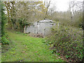
Derelict garage
It is located beside a public footpath and has been constructed of chipboard with a roof of corrugated asbestos.
Image: © John Baker
Taken: 15 Apr 2018
0.01 miles
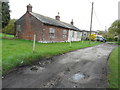
2
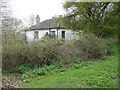
Derelict bungalow
It is located beside a public footpath, a short distance from this Image, which probably formed part of the property. This image shows the Image from the ESE.
Image: © John Baker
Taken: 15 Apr 2018
0.03 miles
3
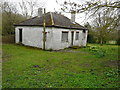
Derelict bungalow
It is located beside a public footpath, a short distance from this Image, which probably formed part of the property. This image shows the Image from the NNE.
Image: © John Baker
Taken: 15 Apr 2018
0.03 miles
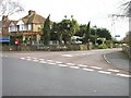
6
Derelict house by a track
The track serves as an access to the house beyond and also as a public footpath.
Image: © John Baker
Taken: 15 Apr 2018
0.08 miles
9
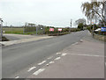
Works access BM11, Shalloak Road
One of three temporary access points to the Richborough Connection Project http://richboroughconnection.co.uk/ which is a proposed 400kV electricity transmission connection between Richborough and Canterbury in Kent to connect the proposed new UK to Belgium interconnector (known as the Nemo Link)
https://infrastructure.planninginspectorate.gov.uk/projects/south-east/richborough-connection-project/
Image: © John Baker
Taken: 15 Apr 2018
0.11 miles
10
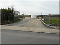
Temporary access entrance, Shalloak Road
This is one of three temporary access points to the Richborough Connection Project http://richboroughconnection.co.uk/ which is a proposed 400kV electricity transmission connection between Richborough and Canterbury in Kent to connect the proposed new UK to Belgium interconnector (known as the Nemo Link)
https://infrastructure.planninginspectorate.gov.uk/projects/south-east/richborough-connection-project/
Its location may be seen in this image of Image
Image: © John Baker
Taken: 15 Apr 2018
0.11 miles