IMAGES TAKEN NEAR TO
Mill Road, CANTERBURY, CT2 0BG
Introduction
This page details the photographs taken nearby to Mill Road, CT2 0BG by members of the Geograph project.
The Geograph project started in 2005 with the aim of publishing, organising and preserving representative images for every square kilometre of Great Britain, Ireland and the Isle of Man.

There are currently over 7.5m images from over14,400 individuals and you can help contribute to the project by visiting https://www.geograph.org.uk
Image Map
Images are licensed for reuse under creativecommons.org/licenses/by-sa/2.0
Notes
- Clicking on the map will re-center to the selected point.
- The higher the marker number, the further away the image location is from the centre of the postcode.
Image Listing (129 Images Found)
Images are licensed for reuse under creativecommons.org/licenses/by-sa/2.0
Image
Details
Distance
2
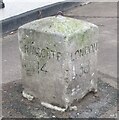
Sturry - Milestone
Ramsgate 14 and London 58 miles from Sturry village centre, NE of Canterbury.
Image: © Colin Smith
Taken: 8 Jan 2018
0.03 miles
3
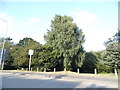
Woodlands by Sturry Hill
These extend to Westbere gravel pits along the railway line.
Image: © David Howard
Taken: 31 Jul 2016
0.03 miles
4
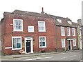
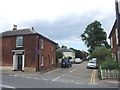
Sturry - High Street
Old red brick buildings, some now used for commercial purposes.
Image: © Colin Smith
Taken: 8 Jan 2018
0.03 miles
5
The former fire station, High Street
Planning permission has been granted by Canterbury City Council under application number CA//13/02269 for the “demolition of former fire station building and construction of seven flats”. David Mills’ view of Image shows it when it was still operational.
Image: © John Baker
Taken: 7 May 2017
0.03 miles
6
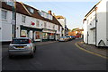
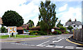
Sturry High St.
Quiet shopping street, now by-passed by the main road.
Image: © N Chadwick
Taken: 27 Sep 2008
0.04 miles
7
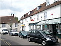
High Street, Sturry
Looking across the road to the, apparently, closed down post office. To the left of the picture is The Swan Inn.
Image: © pam fray
Taken: 12 Jun 2009
0.04 miles
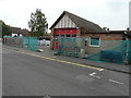
8
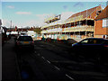
Construction of flats, High Street
Planning permission has been granted by Canterbury City Council under application number CA//13/02269 for the “demolition of former fire station building and construction of seven flats”.
This image shows the Image
Image: © John Baker
Taken: 11 Feb 2018
0.04 miles
9
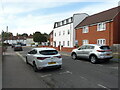
The Old Fire Station, High Street
This view shows the Image
Image: © John Baker
Taken: 9 Aug 2021
0.04 miles