IMAGES TAKEN NEAR TO
Sandgate High Street, FOLKESTONE, CT20 3RR
Introduction
This page details the photographs taken nearby to Sandgate High Street, CT20 3RR by members of the Geograph project.
The Geograph project started in 2005 with the aim of publishing, organising and preserving representative images for every square kilometre of Great Britain, Ireland and the Isle of Man.

There are currently over 7.5m images from over14,400 individuals and you can help contribute to the project by visiting https://www.geograph.org.uk
Image Map
Images are licensed for reuse under creativecommons.org/licenses/by-sa/2.0
Notes
- Clicking on the map will re-center to the selected point.
- The higher the marker number, the further away the image location is from the centre of the postcode.
Image Listing (145 Images Found)
Images are licensed for reuse under creativecommons.org/licenses/by-sa/2.0
Image
Details
Distance
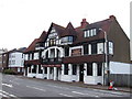
3
Sandgate, Sandgate High Street
Folkestone, Sandgate, 7 Sandgate High Street, Royal Norfolk Hotel, CT20 3BD
Image: © Helmut Zozmann
Taken: 21 Jul 2011
0.01 miles
4
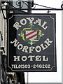
Sandgate, Sandgate High Street
Folkestone, Sandgate, 7 Sandgate High Street, Royal Norfolk Hotel, CT20 3BD, Hotel Sign.
Image: © Helmut Zozmann
Taken: 21 Jul 2011
0.01 miles
6
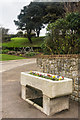
Entrance to Enbrook Park
Former drinking trough at the entrance to Enbrook Park. See Image for close up.
Image: © Ian Capper
Taken: 6 Feb 2016
0.02 miles
7
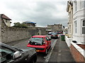
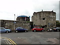
Sandgate, Castle Road
Folkestone, Sandgate, Castle Road, Sandgate Castle.
Sandgate Castle is a coastal castle and was originally built as an artillery castle in 1539-1540 by Henry VIII of England as part of his chain of coastal defences in response to the threat of invasion. As these forts were devised by Henry VIII, they are known as Device Forts. It was built to defend a vulnerable stretch of coastline and due to its proximity to the French coast the site has been constantly defended and refortified.
Image: © Helmut Zozmann
Taken: 21 Jul 2011
0.02 miles
8
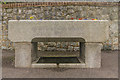
Drinking trough
Close up of the drinking trough in Image, situated at the entrance to Enbrook Park. The inscription reads "Gift of Lt Colonel Wheatley 1877".
Although probably not provided by the Metropolitan Drinking Fountain and Cattle Trough Association, it is of a very similar design to many of theirs.
Image: © Ian Capper
Taken: 6 Feb 2016
0.02 miles
9
Sandgate, Castle Road
Folkestone, Sandgate, Castle Road, Sandgate Castle.
Sandgate Castle is a coastal castle and was originally built as an artillery castle in 1539-1540 by Henry VIII of England as part of his chain of coastal defences in response to the threat of invasion. As these forts were devised by Henry VIII, they are known as Device Forts. It was built to defend a vulnerable stretch of coastline and due to its proximity to the French coast the site has been constantly defended and refortified.
Image: © Helmut Zozmann
Taken: 21 Jul 2011
0.02 miles