IMAGES TAKEN NEAR TO
Laurel Close, FOLKESTONE, CT20 3PP
Introduction
This page details the photographs taken nearby to Laurel Close, CT20 3PP by members of the Geograph project.
The Geograph project started in 2005 with the aim of publishing, organising and preserving representative images for every square kilometre of Great Britain, Ireland and the Isle of Man.

There are currently over 7.5m images from over14,400 individuals and you can help contribute to the project by visiting https://www.geograph.org.uk
Image Map
Images are licensed for reuse under creativecommons.org/licenses/by-sa/2.0
Notes
- Clicking on the map will re-center to the selected point.
- The higher the marker number, the further away the image location is from the centre of the postcode.
Image Listing (52 Images Found)
Images are licensed for reuse under creativecommons.org/licenses/by-sa/2.0
Image
Details
Distance
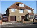
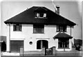
2
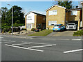
Houses, Shorncliffe Road
The detached house is number 232, while to its right is number 230.
Image: © John Baker
Taken: 17 Sep 2023
0.09 miles
3
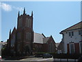
Cheriton Baptist Church
On junction of Cheriton Road (in front) and Queen's Road (on left).
Image: © David Anstiss
Taken: 13 Jun 2009
0.12 miles
4
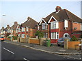
Shorncliffe Road
1930s semis in Coolinge.
Image: © Burgess Von Thunen
Taken: 24 Oct 2012
0.13 miles
5
43, High Street
Image: © John Baker
Taken: 10 Apr 2019
0.13 miles
6
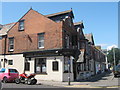
The Royal Cheriton Public House, Folkestone
On junction of 339 Cheriton Road (on right) and St Winifred Road (on left).
Image: © David Anstiss
Taken: 13 Jun 2009
0.14 miles
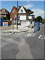
7
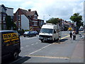
Cheriton, Cheriton Road
Cheriton Road looking West
Image: © Helmut Zozmann
Taken: 22 Jul 2009
0.14 miles
8
Cheriton, Kent
Ilex House, Narrabeen Road, looking towards Caesar's Camp
Image: © Iain Crump
Taken: 16 Feb 2008
0.14 miles
9
Cheriton, Kent
Ilex House, Narrabeen Road, the year it was built. Looking towards Caesar's Camp
Image: © My Grandfather, George Victor Crump...long since deceased
Taken: Unknown
0.14 miles
10
43, High Street
Planning permission was approved, with conditions, by Folkestone and Hythe District Council under application number Y15/0313/SH for the “erection of a 2 storey block of 4 flats following demolition of existing single storey rear shop floor/storage extension”. This image shows the rear of the building from Park Road. The shop was known as the Image
Image: © John Baker
Taken: 18 Jun 2017
0.15 miles