IMAGES TAKEN NEAR TO
St. Pauls Way, FOLKESTONE, CT20 3NX
Introduction
This page details the photographs taken nearby to St. Pauls Way, CT20 3NX by members of the Geograph project.
The Geograph project started in 2005 with the aim of publishing, organising and preserving representative images for every square kilometre of Great Britain, Ireland and the Isle of Man.

There are currently over 7.5m images from over14,400 individuals and you can help contribute to the project by visiting https://www.geograph.org.uk
Image Map
Images are licensed for reuse under creativecommons.org/licenses/by-sa/2.0
Notes
- Clicking on the map will re-center to the selected point.
- The higher the marker number, the further away the image location is from the centre of the postcode.
Image Listing (12 Images Found)
Images are licensed for reuse under creativecommons.org/licenses/by-sa/2.0
Image
Details
Distance
3
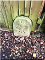
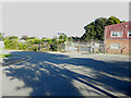
Old Boundary Marker on the B2170 Military Road in Sandgate
War Department Boundary Marker against a wooden fence on the east side of the B2170 Military Road. Sandgate parish. Inscribed 6 / W D / ↑. Stone number 6 is marked at TR2017435642 on old OS maps. Marking the boundary of Shorncliffe Camp.
Milestone Society National ID: KE_WDSAND06em
Image: © P Collins
Taken: 6 Feb 2022
0.21 miles
4
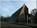
The Brigade of Gurkha's Visitor Centre
A converted church on the junction of North Road and Military Road.
Close to the Sir John Moore Shorncliffe Camp.
See http://www.thegurkhamuseum.co.uk/The_Museum/Other_Museums_And_Centres/14 more details.
Image: © David Anstiss
Taken: 19 Nov 2010
0.21 miles
5
Folkestone - 2013
Folkestone, Kent, Coolinge, St Stephen's Way, Folkestone School for Girls, Martello Tower No. 5 (totally overgrown)
Image: © Helmut Zozmann
Taken: 27 Aug 2013
0.22 miles
6
Martello Tower 5
A very rare look at a Martello tower that has not been seen like this for a very long time.
Tower number 5 is in the grounds of the Folkestone school for girls.
For many years this tower has been covered in trees and brambles until recently when the school was given a grant to clear the site. I was told not even the students knew it was there till now.
A big thanks to the school for giving me the opportunity to see it.
Image: © Ashley Fuggle
Taken: 1 Apr 2016
0.22 miles
7
Folkestone - 2013
Folkestone, Kent, Coolinge, St Stephen's Way, Folkestone School for Girls, Martello Tower No. 5 (totally overgrown)
Image: © Helmut Zozmann
Taken: 27 Aug 2013
0.22 miles
8
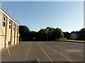
Star Plant Ltd, Ross Way
Planning permission has been approved, with conditions, by Folkestone and Hythe District Council under application number 22/0277/FH for the “erection of 7 new commercial units. New units to include ground floor accommodation and 1st floor mezzanine. Existing units to south-west end of site to be retained”.
Image: © John Baker
Taken: 11 Sep 2022
0.23 miles
9
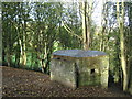
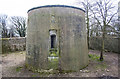
Pillbox near Military Road
This wartime defensive bunker is close to Martello Tower No.6.
Military Road is in the background.
Image: © David Anstiss
Taken: 19 Nov 2010
0.23 miles
10
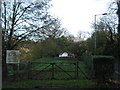
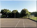
Dog Training Area
This small 'bleak' square recreational area is beside Military Road
Image: © David Anstiss
Taken: 19 Nov 2010
0.24 miles