IMAGES TAKEN NEAR TO
Radnor Cliff, FOLKESTONE, CT20 2TX
Introduction
This page details the photographs taken nearby to Radnor Cliff, CT20 2TX by members of the Geograph project.
The Geograph project started in 2005 with the aim of publishing, organising and preserving representative images for every square kilometre of Great Britain, Ireland and the Isle of Man.

There are currently over 7.5m images from over14,400 individuals and you can help contribute to the project by visiting https://www.geograph.org.uk
Image Map
Images are licensed for reuse under creativecommons.org/licenses/by-sa/2.0
Notes
- Clicking on the map will re-center to the selected point.
- The higher the marker number, the further away the image location is from the centre of the postcode.
Image Listing (123 Images Found)
Images are licensed for reuse under creativecommons.org/licenses/by-sa/2.0
Image
Details
Distance
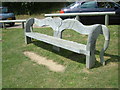
2
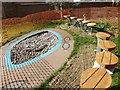
The Look Out and Remember Garden, Folkestone
The Look Out and Remember garden is nearly complete. It is in the Lower Leas Coastal Park and was created by three women who lost their children as a place to remember those who die before their time. The bench on the right was designed by local artist Ara Moradian. It stands at the top of a spiral path that winds down a slope overlooking the Channel. People add stones to the pool in remembrance and, when it is full, the pebbles will be returned to the sea.
Image: © pam fray
Taken: 24 Feb 2017
0.03 miles
4
Folkestone, Lower Leas Coastal Park
Wooden Bench seen in Folkestone's Lower Leas Coastal Park.
Image: © Helmut Zozmann
Taken: 16 Jul 2008
0.04 miles
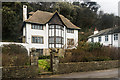
6
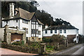
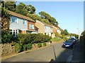
57 Radnor Cliff
Comparison of 6" maps revised in 1938 and 1945 suggest that this large house, along with its neighbour beyond, no 59, was built between these dates.
Image: © Ian Capper
Taken: 6 Feb 2016
0.04 miles
8
57 Radnor Cliff
Comparison of 6" maps revised in 1938 and 1945 suggest that this large house, along with its neighbour on the right, no 59, was built between these dates.
Image: © Ian Capper
Taken: 6 Feb 2016
0.05 miles
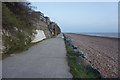
9

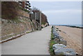
Path to the beach, Folkestone
At the western end of the town, off Lower Sandgate Road. I didn't investigate the source of the 'coastal hazards'.
Image: © pam fray
Taken: 24 Feb 2017
0.05 miles