IMAGES TAKEN NEAR TO
Foster Way, FOLKESTONE, CT20 2TT
Introduction
This page details the photographs taken nearby to Foster Way, CT20 2TT by members of the Geograph project.
The Geograph project started in 2005 with the aim of publishing, organising and preserving representative images for every square kilometre of Great Britain, Ireland and the Isle of Man.

There are currently over 7.5m images from over14,400 individuals and you can help contribute to the project by visiting https://www.geograph.org.uk
Image Map
Images are licensed for reuse under creativecommons.org/licenses/by-sa/2.0
Notes
- Clicking on the map will re-center to the selected point.
- The higher the marker number, the further away the image location is from the centre of the postcode.
Image Listing (86 Images Found)
Images are licensed for reuse under creativecommons.org/licenses/by-sa/2.0
Image
Details
Distance
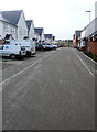
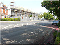
1
Foster Way
This is the entrance to Image from Marten Road. After these houses have been completed and the fence across the road removed, it will be possible to reach Westbrook Drive along this road, rather than from Broadfield Road, which is the means of access at present. The houses are being built on an estate known as the West End Quarter.
This image of Image shows the road after all building work had been completed.
Image: © John Baker
Taken: 6 May 2018
0.01 miles
2

Foster Way
Following the completion of these houses in Image and the removal of a fence across the road, it is now possible to reach Westbrook Road, using a vehicle. These houses are on an estate known as the West End Quarter.
Image: © John Baker
Taken: 22 Jul 2018
0.01 miles
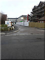
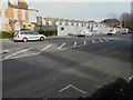
3
Westbrook Drive
These houses have been built on an estate known as the West End Quarter, which is accessible from Marten Road via Broadfield Road.
Image: © John Baker
Taken: 4 Jan 2018
0.03 miles
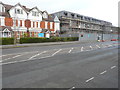
4
Westbrook Drive
The houses at the far and of the road are those nearest to the camera in this image of Image The houses have been built on an estate known as the West End Quarter, which is accessible from Marten Road via Broadfield Road.
Image: © John Baker
Taken: 6 May 2018
0.03 miles
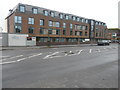
5
Foster Way
At the end of the road the large building is an 80 bedroom nursing home, which is still under construction.
Image: © John Baker
Taken: 4 Jan 2018
0.04 miles
6
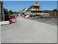
Construction site, Shorncliffe Road
Compared with Image, the nursing home behind the hoarding is now taking shape. Planning permission has been approved, with conditions, by Folkestone and Hythe District Council under application number Y15/0563/SH for a “section 73 application for the variation of conditions 4, 6, 21 and 29 of outline planning permission Y10/0077/SH (outline application for the construction of 127 dwellings (Class C3) and an 80 bedroom nursing home (Class C2) following the demolition of 52 Shorncliffe Road (together with associated access, parking and landscaping) in order to allow amendments to the approved layout, landscaping and the number of units (condition 4)); samples of the proposed materials to be submitted prior to the commencement of development (condition 6); and minor re-wording of conditions 21 and 29 to reflect the commencement of the approved care home”.
The site includes numbers 50, 52 (which was formerly St Mary’s Westbrook School), Image and playing fields (which are mentioned in the outline planning permission Y10/0077/SH).
Image: © John Baker
Taken: 29 May 2016
0.04 miles
7
Building site, Shorncliffe Road
Planning permission has been approved, with conditions, by Folkestone and Hythe District Council under application number Y15/0563/SH for a “section 73 application for the variation of conditions 4, 6, 21 and 29 of outline planning permission Y10/0077/SH (outline application for the construction of 127 dwellings (Class C3) and an 80 bedroom nursing home (Class C2) following the demolition of 52 Shorncliffe Road (together with associated access, parking and landscaping) in order to allow amendments to the approved layout, landscaping and the number of units (condition 4)); samples of the proposed materials to be submitted prior to the commencement of development (condition 6); and minor re-wording of conditions 21 and 29 to reflect the commencement of the approved care home”. The nursing home is being built behind the hoarding.
The site includes numbers 50, 52 (which was formerly St Mary’s Westbrook School), Image and playing fields (which are mentioned in the outline planning permission Y10/0077/SH).
Image: © John Baker
Taken: 10 Dec 2015
0.04 miles
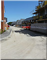
8
Construction site, Shorncliffe Road
Compared with Image, there has been a lot more work carried out to the nursing home and Image still stands, awaiting its demolition. Planning permission has been approved, with conditions, by Folkestone and Hythe District Council under application number Y15/0563/SH as a “section 73 application for the variation of conditions 4, 6, 21 and 29 of outline planning permission Y10/0077/SH (outline application for the construction of 127 dwellings (Class C3) and an 80 bedroom nursing home (Class C2) following the demolition of 52 Shorncliffe Road, together with associated access, parking and landscaping) in order to allow amendments to the approved layout, landscaping and the number of units (condition 4); samples of the proposed materials to be submitted prior to the commencement of development (condition 6); and minor re-wording of conditions 21 and 29 to reflect the commencement of the approved care home”.
The building, on the right, is now Image
Image: © John Baker
Taken: 5 Mar 2017
0.05 miles
9
Folkestone Care Centre, 52-56, Shorncliffe Road
Once it was part of a Image, now it is finished and open to the public.
Image: © John Baker
Taken: 23 Dec 2018
0.05 miles
10
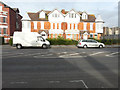
54 & 56, Shorncliffe Road
This was formerly Westbrook House Preparatory School. Planning permission has been approved, with conditions, by Folkestone and Hythe District Council under application number Y15/0563/SH for a “section 73 application for the variation of conditions 4, 6, 21 and 29 of outline planning permission Y10/0077/SH (outline application for the construction of 127 dwellings (Class C3) and an 80 bedroom nursing home (Class C2) following the demolition of 52 Shorncliffe Road (together with associated access, parking and landscaping) in order to allow amendments to the approved layout, landscaping and the number of units (condition 4)); samples of the proposed materials to be submitted prior to the commencement of development (condition 6); and minor re-wording of conditions 21 and 29 to reflect the commencement of the approved care home”.
52, Shorncliffe Road was formerly St Mary’s Westbrook School.
Image: © John Baker
Taken: 10 Dec 2015
0.05 miles