IMAGES TAKEN NEAR TO
Westbourne Gardens, FOLKESTONE, CT20 2HX
Introduction
This page details the photographs taken nearby to Westbourne Gardens, CT20 2HX by members of the Geograph project.
The Geograph project started in 2005 with the aim of publishing, organising and preserving representative images for every square kilometre of Great Britain, Ireland and the Isle of Man.

There are currently over 7.5m images from over14,400 individuals and you can help contribute to the project by visiting https://www.geograph.org.uk
Image Map
Images are licensed for reuse under creativecommons.org/licenses/by-sa/2.0
Notes
- Clicking on the map will re-center to the selected point.
- The higher the marker number, the further away the image location is from the centre of the postcode.
Image Listing (148 Images Found)
Images are licensed for reuse under creativecommons.org/licenses/by-sa/2.0
Image
Details
Distance
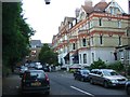
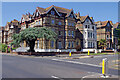
1
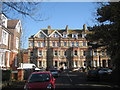
Terraced Houses on Westbourne Gardens
Victorian style with bay windows to ground and first floors.
Image: © Oast House Archive
Taken: 8 Apr 2010
0.04 miles
2
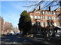
Flats on Westbourne Gardens, Folkestone (1)
These would originally have been grand family houses, but they are now divided into flats. The rear view is shown at Image]
Image: © Danny P Robinson
Taken: 1 Apr 2014
0.04 miles
3
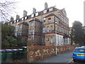
Flats on Westbourne Gardens, Folkestone (2)
These would originally have been grand family houses, but they are now divided into flats. A look to the rear shows them to be in a not particularly good condition. The rear view is shown at Image]
Image: © Danny P Robinson
Taken: 1 Apr 2014
0.04 miles
6
Flats on Westbourne Gardens, Folkestone (3)
Image: © Danny P Robinson
Taken: 1 Apr 2014
0.05 miles

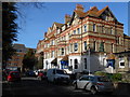
9
162, Sandgate Road
Planning permission has been approved, with conditions, by Folkestone and Hythe District Council under application number 21/1672/FH for the “demolition of 3 garages, retention and conversion of an existing coach house. Erection of a new annexe to the coach house with a surrounding boundary wall, to form a single, self-contained, courtyard dwelling house”.
The coach house is located to the left of the garages and is partly hidden in this view.
Image: © John Baker
Taken: 28 Nov 2021
0.09 miles
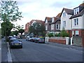
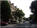
10
Sandgate Road, Folkestone
Seen from the junction with Earl's Avenue, this is an area of large stately villas and broad tree-lined roads. The junction itself forms part of the A259 - heading north along Earl's Avenue and west along Sandgate Road.
Image: © Stephen McKay
Taken: 16 Jun 2023
0.09 miles