IMAGES TAKEN NEAR TO
Earls Avenue, FOLKESTONE, CT20 2HA
Introduction
This page details the photographs taken nearby to Earls Avenue, CT20 2HA by members of the Geograph project.
The Geograph project started in 2005 with the aim of publishing, organising and preserving representative images for every square kilometre of Great Britain, Ireland and the Isle of Man.

There are currently over 7.5m images from over14,400 individuals and you can help contribute to the project by visiting https://www.geograph.org.uk
Image Map (Loading...)


Getting Data...Please wait
Leaflet Map data © OpenStreetMap
Images are licensed for reuse under creativecommons.org/licenses/by-sa/2.0
Notes
- Clicking on the map will re-center to the selected point.
- The higher the marker number, the further away the image location is from the centre of the postcode.
Image Listing (133 Images Found)
Images are licensed for reuse under creativecommons.org/licenses/by-sa/2.0
Image
Details
Distance
1
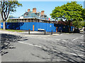
12, Jointon Road
Planning permission was approved, with conditions, by Folkestone and Hythe District Council under application number Y15/0178/SH for the “demolition of rear and side extensions and conversion of existing building to form 2 self-contained dwellings and construction of two blocks to the rear garden to form 6 townhouses”.
This image shows Image in March 2017.
Image: © John Baker
Taken: 6 May 2018
0.04 miles
2
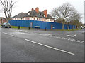
12, Jointon Road
Planning permission has been approved, with conditions, by Folkestone and Hythe District Council under application number Y15/0178/SH for the “demolition of rear and side extensions and conversion of existing building to form 2 self-contained dwellings and construction of two blocks to the rear garden to form 6 townhouses”.
Image: © John Baker
Taken: 5 Mar 2017
0.05 miles
3
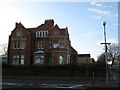
Earlscliffe Adult Education Centre (2)
This large building is on the junction of Earl's Avenue (in front) and Shorncliffe Road (on the right). It has closed and is about to re-developed into 7 flats and 5 houses.
Image: © David Anstiss
Taken: 19 Nov 2010
0.05 miles
4
12, Jointon Road
This image shows Image in May 2018.
Image: © John Baker
Taken: 6 Oct 2019
0.05 miles
5
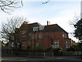
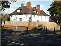
Earlscliffe Adult Education Centre
This large building is on the junction of Earl's Avenue and Shorncliffe Road (in front). It has closed and is about to re-developed into 7 flats and 5 houses.
Image: © David Anstiss
Taken: 19 Nov 2010
0.06 miles
7
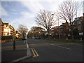
Looking east along Shorncliffe Road
The information board, about a development called West End Quarter, is positioned close to Image and the top of the building is visible here.
Image: © John Baker
Taken: 29 May 2016
0.07 miles
8
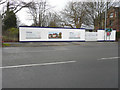
Hoarding advertising Bellway West End Quarter, Shorncliffe Road
It has replaced Image, which formerly stood on this site.
Image: © John Baker
Taken: 5 Mar 2017
0.07 miles
9
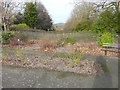
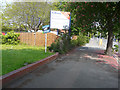
Public garden, Shorncliffe Road
One wonders if the land behind the garden will ever be developed.
Image: © John Baker
Taken: 10 Dec 2015
0.08 miles
10
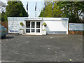
Bellway sales and marketing suite, Shorncliffe Road
The building stands on the site of a Image It has now been replaced by a Image My remark about the fate of the land behind it has been answered, as a development called West End Quarter is to be built on it http://www.bellway.co.uk/
Image: © John Baker
Taken: 29 May 2016
0.08 miles