IMAGES TAKEN NEAR TO
Hayward Gardens, FOLKESTONE, CT20 2FH
Introduction
This page details the photographs taken nearby to Hayward Gardens, CT20 2FH by members of the Geograph project.
The Geograph project started in 2005 with the aim of publishing, organising and preserving representative images for every square kilometre of Great Britain, Ireland and the Isle of Man.

There are currently over 7.5m images from over14,400 individuals and you can help contribute to the project by visiting https://www.geograph.org.uk
Image Map
Images are licensed for reuse under creativecommons.org/licenses/by-sa/2.0
Notes
- Clicking on the map will re-center to the selected point.
- The higher the marker number, the further away the image location is from the centre of the postcode.
Image Listing (111 Images Found)
Images are licensed for reuse under creativecommons.org/licenses/by-sa/2.0
Image
Details
Distance
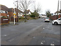
1
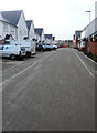
Westbrook Drive
These houses have been built on an estate known as the West End Quarter, which is accessible from Marten Road via Broadfield Road.
Image: © John Baker
Taken: 4 Jan 2018
0.02 miles
2
Westbrook Drive
The houses at the far and of the road are those nearest to the camera in this image of Image The houses have been built on an estate known as the West End Quarter, which is accessible from Marten Road via Broadfield Road.
Image: © John Baker
Taken: 6 May 2018
0.03 miles
3
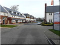
Westbrook Drive
These houses have been built on an estate known as the West End Quarter, which is accessible from Marten Road via Broadfield Road.
Image: © John Baker
Taken: 4 Jan 2018
0.03 miles
5
Broadfield Road
This road leads into Westbrook Drive, where houses have been built on an estate known as the West End Quarter.
Image: © John Baker
Taken: 4 Jan 2018
0.05 miles
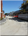
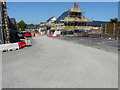
6

Foster Way
Following the completion of these houses in Image and the removal of a fence across the road, it is now possible to reach Westbrook Road, using a vehicle. These houses are on an estate known as the West End Quarter.
Image: © John Baker
Taken: 22 Jul 2018
0.06 miles
7
Foster Way
This is the entrance to Image from Marten Road. After these houses have been completed and the fence across the road removed, it will be possible to reach Westbrook Drive along this road, rather than from Broadfield Road, which is the means of access at present. The houses are being built on an estate known as the West End Quarter.
This image of Image shows the road after all building work had been completed.
Image: © John Baker
Taken: 6 May 2018
0.06 miles
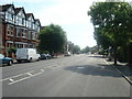
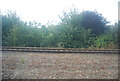
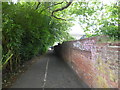
9
Railway bridge over a footpath
A path leads from Shorncliffe Road towards Cheriton Road.
Image: © David Anstiss
Taken: 19 Nov 2010
0.07 miles
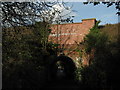
10
Footpath to Cheriton Road
This footpath leads from Shorncliffe Road to Cheriton Road, passing under the railway near Folkestone Central on the way.
Image: © Marathon
Taken: 11 Jun 2017
0.07 miles