IMAGES TAKEN NEAR TO
Varne Road, FOLKESTONE, CT19 6BG
Introduction
This page details the photographs taken nearby to Varne Road, CT19 6BG by members of the Geograph project.
The Geograph project started in 2005 with the aim of publishing, organising and preserving representative images for every square kilometre of Great Britain, Ireland and the Isle of Man.

There are currently over 7.5m images from over14,400 individuals and you can help contribute to the project by visiting https://www.geograph.org.uk
Image Map
Images are licensed for reuse under creativecommons.org/licenses/by-sa/2.0
Notes
- Clicking on the map will re-center to the selected point.
- The higher the marker number, the further away the image location is from the centre of the postcode.
Image Listing (150 Images Found)
Images are licensed for reuse under creativecommons.org/licenses/by-sa/2.0
Image
Details
Distance
2
Folkestone, Wear Bay Road
Folkestone, East Cliff and Wear Bay Road.
Image: © Helmut Zozmann
Taken: 20 Jul 2011
0.05 miles
3
Folkestone, Hasborough Road
Folkestone, Hasborough Road, Martello Tower No. 3 in the distance.
Image: © Helmut Zozmann
Taken: 20 Jul 2011
0.06 miles
4

Common Mallow - 2001
Folkestone, East Cliff, Wear Bay Road, Common Mallow (Malva sylvestris)
Image: © Helmut Zozmann
Taken: 22 Jul 2001
0.06 miles
5

Folkestone - 2015
Folkestone, Kent, East Cliff, Hottentot Fig, Carpobrotus edulis, an introduced plant from South Africa, which is now naturalised in sheltered coastal areas in Britain and Ireland.
Image: © Helmut Zozmann
Taken: 1 Aug 2015
0.07 miles
6
Fire damaged houses, Wear Bay Crescent
The fire started at 13:30 on 30 December 2019. The house that stood here was number 21 (but was so badly damaged that the remains were demolished) and the fire-damaged house, to its right, is number 23. This is number 19 of the Image https://www.kentonline.co.uk/folkestone/news/house-completely-demolished-after-huge-blaze-219419/
Image: © John Baker
Taken: 12 Jan 2020
0.07 miles
8
23-25, Wear Bay Crescent
Planning permission has been granted, with conditions, by Folkestone and Hythe District Council under application number 22/1227/FH for the "erection of two new dwellings with associated parking, bin, bike storage and amenity space".
Taken during a photographic outing on New Year's Day afternoon.
Image: © John Baker
Taken: 1 Jan 2023
0.07 miles
9
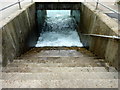
Steps to the beach at Baker's Gap, Folkestone
Inaccessible at high tide.
Image: © pam fray
Taken: 20 Aug 2012
0.07 miles
10
Wear Bay Crescent
There were Image in January 2020 but the fire-gutted house (number 19) has been demolished and hoarding erected.
Image: © John Baker
Taken: 3 Oct 2021
0.07 miles