IMAGES TAKEN NEAR TO
Chart Road, FOLKESTONE, CT19 4EN
Introduction
This page details the photographs taken nearby to Chart Road, CT19 4EN by members of the Geograph project.
The Geograph project started in 2005 with the aim of publishing, organising and preserving representative images for every square kilometre of Great Britain, Ireland and the Isle of Man.

There are currently over 7.5m images from over14,400 individuals and you can help contribute to the project by visiting https://www.geograph.org.uk
Image Map
Images are licensed for reuse under creativecommons.org/licenses/by-sa/2.0
Notes
- Clicking on the map will re-center to the selected point.
- The higher the marker number, the further away the image location is from the centre of the postcode.
Image Listing (79 Images Found)
Images are licensed for reuse under creativecommons.org/licenses/by-sa/2.0
Image
Details
Distance
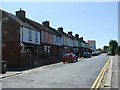
1
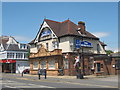
The Morehall Public House, Folkestone
On 284 Cheriton Road.
Image: © David Anstiss
Taken: 13 Jun 2009
0.07 miles
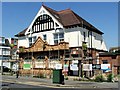
2

Former Morehall public house
Situated at 284 Cheriton Road and also standing on the corner of Coombe Road (to its left). According to the link http://www.dover-kent.com/Morehall-Folkestone.html it opened in 1901 and closed at the end of 2009. Planning permission has been approved, with conditions, by Folkestone and Hythe District Council under application number Y11/0373/SH for the “change of use and conversion of public house to 8 self contained flats incorporating minor external alterations the erection of railings and fencing to the boundaries, a bin/bicycle store, associated parking and removal of the existing garage to the rear”.
Image: © John Baker
Taken: 12 Jan 2014
0.07 miles
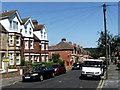
5
Houses on the corner
The corner being where Limes Road meets Cheriton Road. 'Limes Road' appears twice - a modern name plate on posts low down, and an old style plate high on the house.
Image: © Robin Webster
Taken: 16 Jan 2013
0.10 miles
7
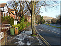
Cherry Garden Avenue
The way out of Folkestone to Junction 13 of the M20, where the motorway becomes the A20 onwards to Dover.
Image: © Robin Webster
Taken: 16 Jan 2013
0.11 miles
10
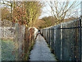
Footpath, Morehall
Morehall Primary School is to the left, a playing field to the right.
Image: © Robin Webster
Taken: 16 Jan 2013
0.14 miles