IMAGES TAKEN NEAR TO
Acrise, FOLKESTONE, CT18 8LW
Introduction
This page details the photographs taken nearby to CT18 8LW by members of the Geograph project.
The Geograph project started in 2005 with the aim of publishing, organising and preserving representative images for every square kilometre of Great Britain, Ireland and the Isle of Man.

There are currently over 7.5m images from over14,400 individuals and you can help contribute to the project by visiting https://www.geograph.org.uk
Image Map
Images are licensed for reuse under creativecommons.org/licenses/by-sa/2.0
Notes
- Clicking on the map will re-center to the selected point.
- The higher the marker number, the further away the image location is from the centre of the postcode.
Image Listing (44 Images Found)
Images are licensed for reuse under creativecommons.org/licenses/by-sa/2.0
Image
Details
Distance
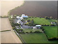
1
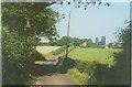
The silage towers of Blandred Farm
The road is called Reece Lane and the cottage to the left of the towers - Candlespur.
Image: © John Baker
Taken: 19 Jul 2000
0.01 miles
2
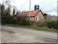
Holly Lodge, Reece Lane
The extension was built in 2016 to form annex accommodation. The silage tower belongs to Blandred Farm.
Image: © John Baker
Taken: 8 Mar 2019
0.02 miles
3
Looking NE along footpath through Blandred Farm
The footpath is shown on the map as following this road but I didn't walk it so I'm not sure of the exact route
Image: © Nick Smith
Taken: 9 Jun 2008
0.03 miles
5
Coming in to land, Acrise
Descending in a hot air balloon towards Blandred Farm, Reece Lane where the landing is about to take place in the field on the right.
Image: © pam fray
Taken: 26 Aug 2016
0.04 miles
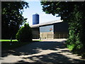
6
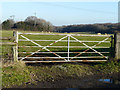
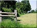
View over a gate in Reece Lane
Stony Lane Wood lies beyond the meadow.
Image: © John Baker
Taken: 17 Dec 2016
0.04 miles
7
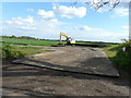
Recycled material
This had been delivered, the previous day by a fleet of lorries, for the use of the owner of Blandred Farm by Viridor, which is a company that recycles waste material into a usable product http://www.viridor.co.uk/ The sign, on the right hand side of the entrance, bears the words Viridor TP and an arrow pointing to the right .
Image: © John Baker
Taken: 20 May 2015
0.05 miles
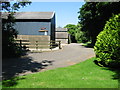
8
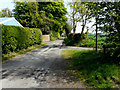
Reece Lane
Nick Smith’s Image shows the lane before the entrance wall to Hawthorn Cottage was constructed.
Image: © John Baker
Taken: 27 Apr 2020
0.05 miles
10
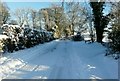
Reece Lane, Acrise
The tree on the right divides the track from Winterdown Farm and Winterdown Cottage so that the lane can be accessed to either the Elham or Swingfield directions.
Image: © John Baker
Taken: 3 Dec 2010
0.06 miles