IMAGES TAKEN NEAR TO
Acrise, FOLKESTONE, CT18 8LA
Introduction
This page details the photographs taken nearby to CT18 8LA by members of the Geograph project.
The Geograph project started in 2005 with the aim of publishing, organising and preserving representative images for every square kilometre of Great Britain, Ireland and the Isle of Man.

There are currently over 7.5m images from over14,400 individuals and you can help contribute to the project by visiting https://www.geograph.org.uk
Image Map
Images are licensed for reuse under creativecommons.org/licenses/by-sa/2.0
Notes
- Clicking on the map will re-center to the selected point.
- The higher the marker number, the further away the image location is from the centre of the postcode.
Image Listing (17 Images Found)
Images are licensed for reuse under creativecommons.org/licenses/by-sa/2.0
Image
Details
Distance
1
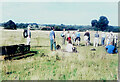
Enjoying a breather
Members of Ashford Ramblers had stopped during a walk from Image, where picnics had been eaten on one of the lawns, to Lyminge Image, from where the walk had started and would end.
The scenery is typical of the North Downs AONB (Area of Outstanding Natural Beauty).
Image: © John Baker
Taken: 24 Sep 2006
0.03 miles
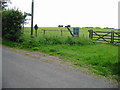
2
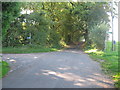
Lane junction near Willow Wood
An unnamed lane leads from Shuttlesfield, past Willow Wood towards Teddars Leas Road. Another lane leads left towards Paddlesworth.
Image: © David Anstiss
Taken: 10 Oct 2010
0.03 miles
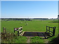
3
Looking S from field entrance near Shuttlesfield
A small pond http://www.geograph.org.uk/photo/867828 is in the area fenced off from the sheep.
Image: © Nick Smith
Taken: 20 Jun 2008
0.04 miles
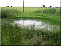
5
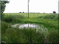
Small pond at the edge of the road to Shuttlesfield
Image: © Nick Smith
Taken: 20 Jun 2008
0.04 miles
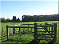
6
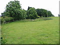
Bridleway towards Lyminge
The bridleway heads to Lyminge via Great Shuttlesfield Farm across land used by the military for training, hence the signs on the fence and gate.
Image: © Nick Smith
Taken: 20 Jun 2008
0.04 miles
7
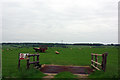
Cattlegrid near Willow Wood
This field entrance leads into a land near Great Shuttlesfield Farm, used by the MOD (Ministry of Defence) as training ground.
Image: © David Anstiss
Taken: 10 Oct 2010
0.07 miles
8
Bridle gates near Tan Barn
These gates are on a bridleway from Great Shuttlesfield Farm, towards the lane near Tan Barn. In the background is Willow Wood.
Image: © David Anstiss
Taken: 10 Oct 2010
0.08 miles
9
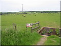
Cattle-grid to military training land
The sign warns of a military training land, which is heavily disguised as ordinary farmland. The field on the other side of the lane is similar and has a similar cattle-grid opposite this one. These are probably to allow unhindered movement of military equipment.
Image: © Robin Webster
Taken: 22 May 2007
0.08 miles
10
Looking E across farmland from the road to Shuttlesfield
A similar view to http://www.geograph.org.uk/photo/441302 13 months later
Image: © Nick Smith
Taken: 20 Jun 2008
0.10 miles