IMAGES TAKEN NEAR TO
Mayfield Road, FOLKESTONE, CT18 8HW
Introduction
This page details the photographs taken nearby to Mayfield Road, CT18 8HW by members of the Geograph project.
The Geograph project started in 2005 with the aim of publishing, organising and preserving representative images for every square kilometre of Great Britain, Ireland and the Isle of Man.

There are currently over 7.5m images from over14,400 individuals and you can help contribute to the project by visiting https://www.geograph.org.uk
Image Map
Images are licensed for reuse under creativecommons.org/licenses/by-sa/2.0
Notes
- Clicking on the map will re-center to the selected point.
- The higher the marker number, the further away the image location is from the centre of the postcode.
Image Listing (130 Images Found)
Images are licensed for reuse under creativecommons.org/licenses/by-sa/2.0
Image
Details
Distance
3

St Ethelburga's Well at Lyminge
The nearby church of St Mary and St Ethelburga is one of the early shrines of Christianity in Kent. In 633 AD, Ethelburga, daughter of King Ethelbert and widow of the King of Northumbria, and Bishop Paulinus founded an abbey for men and women. Its last known charter survives and part of the original abbey survives in the present church.
The well situated along Well Road and above Tayne Field Recreation Ground is clearly ancient, although the housing is more modern. It emits a headstream of the Nail Bourne which flows through the recreation ground - see http://www.geograph.org.uk/photo/4565507 Some more information can be seen at http://www.megalithic.co.uk/article.php?sid=12861
Image: © Marathon
Taken: 10 Jul 2015
0.02 miles
4

St Ethelburga's Well at Lyminge seen from Tayne Field Recreation Ground
The nearby church of St Mary and St Ethelburga is one of the early shrines of Christianity in Kent. In 633 AD, Ethelburga, daughter of King Ethelbert and widow of the King of Northumbria, and Bishop Paulinus founded an abbey for men and women. Its last known charter survives and part of the original abbey survives in the present church.
The well situated between Well Road and Tayne Field Recreation Ground is clearly ancient, although the housing is more modern. It emits a headstream of the Nail Bourne which flows through the recreation ground - see http://www.geograph.org.uk/photo/4565507 Some more information can be seen at http://www.megalithic.co.uk/article.php?sid=12861
Image: © Marathon
Taken: 10 Jul 2015
0.02 miles
5
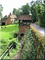
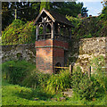
Well house for Ethelburga's Well
The well house is on the site of a spring which is probably the main source of the river Nailbourne which flows through the Elham Valley. The canopy and chain pump were erected in 1898.
Image: © Nick Smith
Taken: 6 Sep 2008
0.02 miles
6
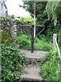
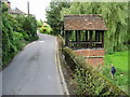
Turnstile at the top of the steps leading to Tayne field
It isn't obvious what the purpose of the turnstile is, there appears to be enough room to get a bicycle or even small motorcycle through the gap.
Image: © Nick Smith
Taken: 6 Sep 2008
0.02 miles
7
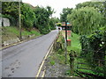
Looking W along Well Road
So named because of a well, the housing for which can be seen in the centre of the photo.
Image: © Nick Smith
Taken: 6 Sep 2008
0.02 miles
8

St Ethelburga's Well at Lyminge
The nearby church of St Mary and St Ethelburga is one of the early shrines of Christianity in Kent. In 633 AD, Ethelburga, daughter of King Ethelbert and widow of the King of Northumbria, and Bishop Paulinus founded an abbey for men and women. Its last known charter survives and part of the original abbey survives in the present church.
The well situated along Well Road and above Tayne Field Recreation Ground is clearly ancient, although the housing is more modern. It emits a headstream of the Nail Bourne which flows through the recreation ground - see http://www.geograph.org.uk/photo/4565507 Some more information can be seen at http://www.megalithic.co.uk/article.php?sid=12861
Image: © Marathon
Taken: 10 Jul 2015
0.02 miles
9
St Ethelburga's Well, Lyminge
Grade II Listed Building - see https://historicengland.org.uk/listing/the-list/list-entry/1242250
Image: © Ian Taylor
Taken: 7 Sep 2017
0.02 miles
10
Ethelburga's Well on Well Road
The well house is on the site of a spring which is probably the main source of the river Nailbourne which flows through the Elham Valley. The canopy and chain pump were erected in 1898.
Image: © Nick Smith
Taken: 6 Sep 2008
0.02 miles