IMAGES TAKEN NEAR TO
Nash Hill, FOLKESTONE, CT18 8ED
Introduction
This page details the photographs taken nearby to Nash Hill, CT18 8ED by members of the Geograph project.
The Geograph project started in 2005 with the aim of publishing, organising and preserving representative images for every square kilometre of Great Britain, Ireland and the Isle of Man.

There are currently over 7.5m images from over14,400 individuals and you can help contribute to the project by visiting https://www.geograph.org.uk
Image Map
Images are licensed for reuse under creativecommons.org/licenses/by-sa/2.0
Notes
- Clicking on the map will re-center to the selected point.
- The higher the marker number, the further away the image location is from the centre of the postcode.
Image Listing (123 Images Found)
Images are licensed for reuse under creativecommons.org/licenses/by-sa/2.0
Image
Details
Distance
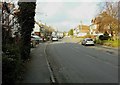
1
Lyminge station
This station was on the Canterbury West to Folkestone line which was opened by the South Eastern Railway in 1887 and closed in 1947. The station buildings have now been restored and are used as a public library.
Image: © David Kemp
Taken: 17 Mar 2007
0.04 miles
2
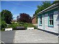
Lyminge: former station, now public library, 2010
View east: Canterbury left, Shorncliffe and Folkestone right: originally on the SE&CR Elham Valley (Canterbury West - Shorncliffe) branch, it was closed to passengers on 2/12/40, when it was taken over by the Army until 3/44 - although civilian passengers from/to Shorncliffe were accepted until 3/5/43. Goods traffic - notably the massive 18 in. 'Boche-Buster', continued until the line was closed completely 1/10/47. (See Image for precisely the same view in winter).
Image: © Ben Brooksbank
Taken: 22 Sep 2010
0.05 miles
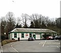
3
The former Lyminge station
The Elham Valley Railway opened in 1887 and closed completely in 1947. Most of the stations along the line closed to passengers in 1940 but a shuttle service from Folkestone to Lyminge operated between 7th October 1946 and 16th June 1947. The line closed completely on 1st October 1947 and the track through Lyminge was lifted in the late summer of 1953. All the information about the Elham Valley Railway and Lyminge station is given here - http://www.disused-stations.org.uk/l/lyminge/
In the late 1980s the station building, seen here, was renovated and is now Lyminge Library. The platforms were on the far side.
Image: © Marathon
Taken: 10 Jul 2015
0.05 miles
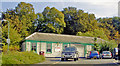
4
Platform of the former Lyminge station
The Elham Valley Railway opened in 1887 and closed completely in 1947. Most of the stations along the line closed to passengers in 1940 but a shuttle service from Folkestone to Lyminge operated between 7th October 1946 and 16th June 1947. The line closed completely on 1st October 1947 and the track through Lyminge was lifted in the late summer of 1953. All the information about the Elham Valley Railway and Lyminge station is given here - http://www.disused-stations.org.uk/l/lyminge/
In the late 1980s the station building was renovated and is now Lyminge Library. This is to the left of the fence here. A view of this can be seen at http://www.geograph.org.uk/photo/4565470
Image: © Marathon
Taken: 10 Jul 2015
0.05 miles
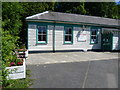
5
The former Lyminge station
The Elham Valley Railway opened in 1887 and closed completely in 1947. Most of the stations along the line closed to passengers in 1940 but a shuttle service from Folkestone to Lyminge operated between 7th October 1946 and 16th June 1947. The line closed completely on 1st October 1947 and the track through Lyminge was lifted in the late summer of 1953. All the information about the Elham Valley Railway and Lyminge station is given here - http://www.disused-stations.org.uk/l/lyminge/
In the late 1980s the station building, seen here on the right, was renovated and is now Lyminge Library. The platforms were on the far side. Another view can be seen at http://www.geograph.org.uk/photo/4565470
Image: © Marathon
Taken: 10 Jul 2015
0.06 miles
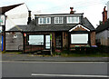
6
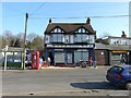
Quick Check, Station Road
It appeared that modifications were being made, to incorporate a ramp, for the disabled to reach the entrance more easily.
Image: © John Baker
Taken: 8 Mar 2015
0.07 miles
7
Quick Check, Station Road
Compared with Image, all remedial work, that was taking place to the entrance to the store, has been completed.
Image: © John Baker
Taken: 30 Mar 2015
0.07 miles
8
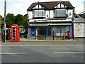
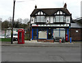
Former Post Office & Convenience Stores, 13, Station Road
Image: © John Baker
Taken: 22 May 2022
0.07 miles
9
15, Station Road
These premises used to be named Spicy Touch Indian Takeaway.
Image: © John Baker
Taken: 22 May 2022
0.08 miles