IMAGES TAKEN NEAR TO
Red House Lane, FOLKESTONE, CT18 8EA
Introduction
This page details the photographs taken nearby to Red House Lane, CT18 8EA by members of the Geograph project.
The Geograph project started in 2005 with the aim of publishing, organising and preserving representative images for every square kilometre of Great Britain, Ireland and the Isle of Man.

There are currently over 7.5m images from over14,400 individuals and you can help contribute to the project by visiting https://www.geograph.org.uk
Image Map
Images are licensed for reuse under creativecommons.org/licenses/by-sa/2.0
Notes
- Clicking on the map will re-center to the selected point.
- The higher the marker number, the further away the image location is from the centre of the postcode.
Image Listing (23 Images Found)
Images are licensed for reuse under creativecommons.org/licenses/by-sa/2.0
Image
Details
Distance
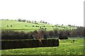
1
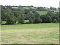
Downland to the E of the Elham Valley Way
Image: © Nick Smith
Taken: 6 Sep 2008
0.08 miles
2
View of the route of the Elham Valley Railway
As seen from Image
This shows the route of the disused and dismantled railway that once led towards Etchinghill. Now just part of Bridge Farm.
Image: © David Anstiss
Taken: 10 Oct 2010
0.10 miles
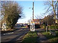
3
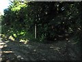
Track junction near Lyminge
A track from Station Road, divides here a farm access track leads left towards Red House Farm. Also a byway heads right towards Teddars Leas Road.
Image: © David Anstiss
Taken: 10 Oct 2010
0.10 miles
4
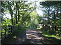
Track bridge near Red House Farm
This track bridge leads from the farm and a byway towards Station Road, Lyminge.
The bridge leads over the disused Elham Valley Railway.
Image: © David Anstiss
Taken: 10 Oct 2010
0.12 miles
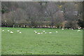
5
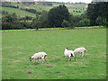
Sheep grazing the downs to the E of footpath
Image: © Nick Smith
Taken: 6 Sep 2008
0.13 miles
6
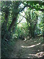
Byway to Teddars Leas Road
This track leads up from Red House Farm neat Lyminge towards the lane leading towards Paddlesworth and Arpinge.
Image: © David Anstiss
Taken: 10 Oct 2010
0.14 miles
7
Development land
For a small housing estate of 30, 2, 3 and 4 bedroom houses.
Image: © John Baker
Taken: 29 May 2022
0.14 miles
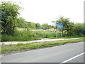
9
Station Road enters Lyminge
Broad Street from Newbarn becomes Station Road heading into the Village.
On the right is a concrete trough with a plaque on which reads 'Erected by this Council to commemorate the Golden Jubilee of the reign of her majesty Queen Elizabeth II 1952 - 2002'.
Image: © David Anstiss
Taken: 30 Jan 2010
0.17 miles