IMAGES TAKEN NEAR TO
Main Road, FOLKESTONE, CT18 8BN
Introduction
This page details the photographs taken nearby to Main Road, CT18 8BN by members of the Geograph project.
The Geograph project started in 2005 with the aim of publishing, organising and preserving representative images for every square kilometre of Great Britain, Ireland and the Isle of Man.

There are currently over 7.5m images from over14,400 individuals and you can help contribute to the project by visiting https://www.geograph.org.uk
Image Map
Images are licensed for reuse under creativecommons.org/licenses/by-sa/2.0
Notes
- Clicking on the map will re-center to the selected point.
- The higher the marker number, the further away the image location is from the centre of the postcode.
Image Listing (20 Images Found)
Images are licensed for reuse under creativecommons.org/licenses/by-sa/2.0
Image
Details
Distance
1
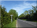
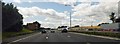
Ashford Road (A20)
The footpath to the left leads to Summerhouse Hill - see http://www.geograph.org.uk/photo/5797298
Image: © Marathon
Taken: 27 May 2018
0.12 miles
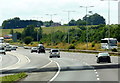
2
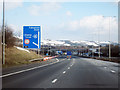
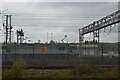
M20 Motorway
Approaching junction 11a.
Image: © Oast House Archive
Taken: 15 Feb 2010
0.14 miles
4
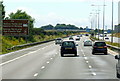
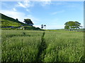
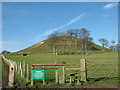
The path to Summerhouse Hill
Travelling along the M20 towards Folkestone and Dover, Summerhouse Hill is the distinctive conical hill seen on the left, just before the Channel Tunnel terminal is reached. Its chalk slopes are quite steep but there are fine views from the top and because of its position it is possible on a clear day to see the French coast well beyond Boulogne to the south. See
https://www.geograph.org.uk/photo/2167121 for more information about Summerhouse Hill.
In this photograph the hill rises to the left as seen from the footpath leading from Ashford Road (A20).
Image: © Marathon
Taken: 27 May 2018
0.17 miles
5
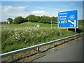
Traffic queuing to enter the Channel tunnel terminal
Image: © Steve Fareham
Taken: 25 Jul 2015
0.17 miles
7
The path to Summerhouse Hill
Travelling along the M20 towards Folkestone and Dover, Summerhouse Hill is the distinctive conical hill seen on the left, just before the Channel Tunnel terminal is reached. Its chalk slopes are quite steep but there are fine views from the top and because of its position it is possible on a clear day to see the French coast well beyond Boulogne to the south. See
https://www.geograph.org.uk/photo/2167121 for more information about Summerhouse Hill.
In this photograph the hill rises to the left as seen from the footpath leading from Ashford Road (A20).
Image: © Marathon
Taken: 27 May 2018
0.18 miles
10
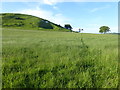
Footpath junction near Summerhouse Hill
A footpath leads from Canterbury Road to Bluehouse Lane (byway) past the Hill (in the background). Another footpath heads right (in front of the stile) towards Beachborough House, or left to the A20 Ashford Road.
Image: © David Anstiss
Taken: 19 Nov 2010
0.20 miles