IMAGES TAKEN NEAR TO
Teddars Leas, FOLKESTONE, CT18 8AE
Introduction
This page details the photographs taken nearby to Teddars Leas, CT18 8AE by members of the Geograph project.
The Geograph project started in 2005 with the aim of publishing, organising and preserving representative images for every square kilometre of Great Britain, Ireland and the Isle of Man.

There are currently over 7.5m images from over14,400 individuals and you can help contribute to the project by visiting https://www.geograph.org.uk
Image Map
Images are licensed for reuse under creativecommons.org/licenses/by-sa/2.0
Notes
- Clicking on the map will re-center to the selected point.
- The higher the marker number, the further away the image location is from the centre of the postcode.
Image Listing (14 Images Found)
Images are licensed for reuse under creativecommons.org/licenses/by-sa/2.0
Image
Details
Distance
1
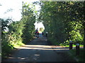
Shearins Leas Farm
Shown on the maps as Shearins (without a g) Leas Farm, but the sign at the farm has a 'g' in it.
Image: © Nick Smith
Taken: 6 Sep 2008
0.01 miles
2
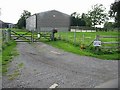
Entrance to Shearins Leas Farm
Marked on all the maps as Shearins Leas, note the spelling on the sign - with a 'g', ie 'Shearingleas Farm'.
Image: © Nick Smith
Taken: 6 Sep 2008
0.04 miles
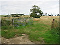
3
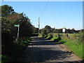
Footpath across a lane
The footpath, also marked as a 'trackway' connects Teddars Leas Road to Paddlesworth
Image: © Nick Smith
Taken: 6 Sep 2008
0.09 miles
4
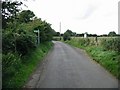
Footpath crosses Teddars Leas Road
Teddars Leas Road heads from Paddlestone towards Etchinghill.
The footpath on the left leads past Shearins Farm to Coel-Na-Mars on the road.
The footpath on the right heads (on an old trackway) to Paddlesworth.
Image: © David Anstiss
Taken: 10 Oct 2010
0.09 miles
5
Congestion on Teddars Leas Road
This road leads from Etchinghill towards Paddlesworth. A horserider, cyclist and two walkers head along the lane, near Shearins Farm.
Image: © David Anstiss
Taken: 10 Oct 2010
0.12 miles
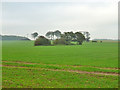
6
Looking NE across farmland near Shearins Leas Farm
Image: © Nick Smith
Taken: 6 Sep 2008
0.17 miles
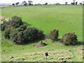
7
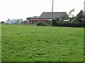
Farmland near Shearins Leas Farm
The near few trees are the remains of a small wood which was about 1-1/2 acres in Victorian times. It is strange this tiny fragment was left after the rest was removed from the 1930s onwards.
Image: © Robin Webster
Taken: 28 Oct 2014
0.19 miles
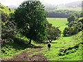
9

The North Downs Way near Shearins Farm
Looking towards Etchinghill.
Image: © Dave Kelly
Taken: 22 Apr 2016
0.21 miles
10
Climbing up the escarpment on to the North Downs
The Pilgrims Way footpath climbs ~100 metres in a short distance, the contours are quite close together on the map.
Image: © Nick Smith
Taken: 6 Sep 2008
0.22 miles