IMAGES TAKEN NEAR TO
Paddlesworth, FOLKESTONE, CT18 8AD
Introduction
This page details the photographs taken nearby to CT18 8AD by members of the Geograph project.
The Geograph project started in 2005 with the aim of publishing, organising and preserving representative images for every square kilometre of Great Britain, Ireland and the Isle of Man.

There are currently over 7.5m images from over14,400 individuals and you can help contribute to the project by visiting https://www.geograph.org.uk
Image Map
Images are licensed for reuse under creativecommons.org/licenses/by-sa/2.0
Notes
- Clicking on the map will re-center to the selected point.
- The higher the marker number, the further away the image location is from the centre of the postcode.
Image Listing (50 Images Found)
Images are licensed for reuse under creativecommons.org/licenses/by-sa/2.0
Image
Details
Distance
3
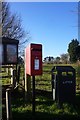
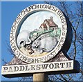
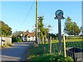
Paddlesworth village sign
Featuring St. Oswald's, said to be the highest church in Kent http://www.hawkinge.com/Map/paddlesworth.HTM , and the "Cat and Custard Pot", which is the name of the local pub http://www.hawkinge.com/CandCP/candcpmystery.htm . We would be interested to know when and why it was the "smallest parish, poorest people".
The location of the sign can be seen here Image .
Image: © Rose and Trev Clough
Taken: 13 Oct 2009
0.01 miles
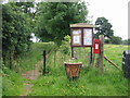
5
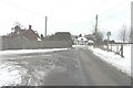
Paddlesworth village centre
The road immediately left heads towards School Road, Acrise. In the distance, the road to the left heads towards Hawkinge and that to the right towards Arpinge. The Cat and Custard Pot public house sits between these roads; a new board has been erected in front of it to advertise its name. Nearer the photographer is the village sign for Paddlesworth. In places the road surface was extremely slippery, where there was a layer of ice.
Image: © John Baker
Taken: 24 Jan 2013
0.03 miles
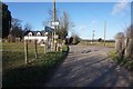
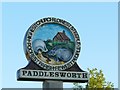
6
Entering Paddlesworth from the west
The road ahead forks, on either side of the Cat and Custard Pot pub - see http://www.geograph.org.uk/photo/851784 .
Image shows more detail of the artwork.
Image: © Rose and Trev Clough
Taken: 13 Oct 2009
0.03 miles
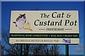
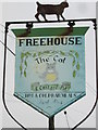
7
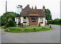
The highest pub in Kent, The Cat and Custard Pot
Several explanantions for the pub's name exist http://www.hawkinge.com/CandCP/ and it claims to be the highest pub in Kent, at 185m above sea level it may well be.
Image: © Nick Smith
Taken: 20 Jun 2008
0.03 miles