IMAGES TAKEN NEAR TO
Curlew Place, FOLKESTONE, CT18 7TD
Introduction
This page details the photographs taken nearby to Curlew Place, CT18 7TD by members of the Geograph project.
The Geograph project started in 2005 with the aim of publishing, organising and preserving representative images for every square kilometre of Great Britain, Ireland and the Isle of Man.

There are currently over 7.5m images from over14,400 individuals and you can help contribute to the project by visiting https://www.geograph.org.uk
Image Map
Images are licensed for reuse under creativecommons.org/licenses/by-sa/2.0
Notes
- Clicking on the map will re-center to the selected point.
- The higher the marker number, the further away the image location is from the centre of the postcode.
Image Listing (88 Images Found)
Images are licensed for reuse under creativecommons.org/licenses/by-sa/2.0
Image
Details
Distance
1
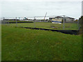
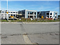
Employment land, Hurricane Way
The crane’s jib marks the location of the Image, while the noticeboard advises interested parties to contact the chartered surveyors and estate agents Smith-Wooley & Perry, whose main office is at Image The large building beyond the employment land is Image
Image: © John Baker
Taken: 23 Oct 2015
0.11 miles
2

Building site, plot 1, Hurricane Way
Compared with Image, the girders of two more large buildings have been erected during the time this site was last photographed.
Planning permission was approved, with conditions, by Folkestone and Hythe District Council under application number Y15/1035/SH for “mixed use development comprising 2366sqm of commercial space (Class B1/B8) in five blocks, together with erection of 47 dwellings, with associated car parking, external works and landscaping (alternative to planning permission Y10/0738/SH)”.
Image: © John Baker
Taken: 8 Mar 2018
0.11 miles
3
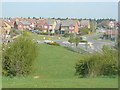
Haven Drive, Hawkinge
During the construction of the estate, a mound of earth, about 15 feet high, was left to the south of Haven Drive. This has been grassed over and planted with trees to form a viewpoint and this is where this view was taken from.
Image: © John Baker
Taken: 15 Apr 2011
0.11 miles
4

Building site, plot 1, Hurricane Way
Compared with Image, this view was taken a little distance from the entrance, as it provides a better perspective of the ongoing work of the site. Planning permission has been approved, with conditions, by Folkestone and Hythe District Council under application number Y15/1035/SH for “mixed use development comprising 2366sqm of commercial space (Class B1/B8) in five blocks, together with erection of 47 dwellings, with associated car parking, external works and landscaping (alternative to planning permission Y10/0738/SH)”.
Image: © John Baker
Taken: 4 Jun 2017
0.12 miles
5
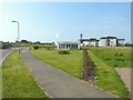
Pentland Homes office, Hurricane Way, Hawkinge
Until recently, this view was obstructed by a car towing a “café on wheels” which was parked on a road that sees a lot of traffic to and from a Lidl supermarket as well as a care home. Now, there is a notice that says that the road is private (if you please!) and that anyone parking on it will be clamped. I took this building when cladding was being added Image
Image: © John Baker
Taken: 10 Aug 2012
0.12 miles
6
Building site, plot 1, Hurricane Way
Another building is under construction while another to its left had had its cladding added.
Planning permission was approved, with conditions, by Folkestone and Hythe District Council under application number Y15/1035/SH for “mixed use development comprising 2366sqm of commercial space (Class B1/B8) in five blocks, together with erection of 47 dwellings, with associated car parking, external works and landscaping (alternative to planning permission Y10/0738/SH)”.
Image: © John Baker
Taken: 17 Aug 2018
0.12 miles
7
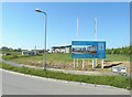
Information board, Hurricane Way, Hawkinge
A close-up view of Image gives full details of the development. The single storey building is the office of Pentland Homes. The area in front of it has been planted with shrubs and a lawn laid. The building in the background is Hawkinge House - a residential care home.
Image: © John Baker
Taken: 25 May 2012
0.12 miles
8
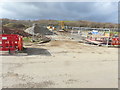
Building site, plot 1, Hurricane Way
Compared with Image, cladding has been installed on the two large buildings.
Planning permission was approved, with conditions, by Folkestone and Hythe District Council under application number Y15/1035/SH for “mixed use development comprising 2366sqm of commercial space (Class B1/B8) in five blocks, together with erection of 47 dwellings, with associated car parking, external works and landscaping (alternative to planning permission Y10/0738/SH)”.
Image: © John Baker
Taken: 17 Aug 2018
0.12 miles
9

Equipment storage, Hurricane Way
Planning permission has been approved, with conditions, by Folkestone and Hythe District Council under application number Y15/1179/SH for the “erection of retail store, and alterations to car park layout, following demolition of existing retail store”. This application relates to the Lidl Food Store in Haven Drive. One of the reasons, for the redevelopment of the site, is that it is prone to flooding, so it is possible that this site is being used for the storage of equipment, connected to the redevelopment of the Lidl Food Store, which can be seen beyond the large concrete rings. The store is due to close on 31 December 2016.
Image: © John Baker
Taken: 24 Nov 2016
0.12 miles
10
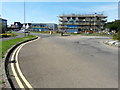
Entrance to building site, plot 1, Hurricane Way
Planning permission has been approved, with conditions, by Folkestone and Hythe District Council under application number Y15/1035/SH for “mixed use development comprising 2366sqm of commercial space (Class B1/B8) in five blocks, together with erection of 47 dwellings, with associated car parking, external works and landscaping (alternative to planning permission Y10/0738/SH)”.
Image: © John Baker
Taken: 5 Mar 2017
0.12 miles