IMAGES TAKEN NEAR TO
Park Close, FOLKESTONE, CT18 7QD
Introduction
This page details the photographs taken nearby to Park Close, CT18 7QD by members of the Geograph project.
The Geograph project started in 2005 with the aim of publishing, organising and preserving representative images for every square kilometre of Great Britain, Ireland and the Isle of Man.

There are currently over 7.5m images from over14,400 individuals and you can help contribute to the project by visiting https://www.geograph.org.uk
Image Map
Images are licensed for reuse under creativecommons.org/licenses/by-sa/2.0
Notes
- Clicking on the map will re-center to the selected point.
- The higher the marker number, the further away the image location is from the centre of the postcode.
Image Listing (99 Images Found)
Images are licensed for reuse under creativecommons.org/licenses/by-sa/2.0
Image
Details
Distance
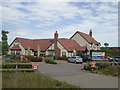
1
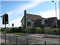
The Mayfly Public House, Hawkinge
On roundabout junction of A260 Spitfire Way (in front) and Haven Drive (unseen to right).
Image: © David Anstiss
Taken: 25 Apr 2009
0.09 miles
3
Looking north from Terlingham Forum
On the left the blue hoarding hides the Image, on the right, behind the tall steel fence, are the contractor's buildings; the Mayfly public house is to the right of these.
Image: © John Baker
Taken: 11 Oct 2013
0.10 miles
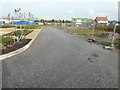
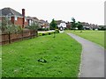
4
Commercial buildings, Hurricane Way
Before the buildings were completed, this was a Image
Image: © John Baker
Taken: 27 Mar 2019
0.11 miles
5

Progress of the development of land adjoining The Mayfly, Defiant Close
Last photographed on 27 May 2014, the Image was taken from the end of the road seen in the distance. Planning permission has been approved, with conditions, by Folkestone and Hythe District Council under application number Y10/0739/SH for a “mixed used development comprising the erection of 4, three storey blocks providing 8 ground floor commercial units (Classes A1, A2, A3, B1 uses) and 48, two bedroom apartments above, together with associated access, parking, landscaping and open space”. The Mayfly refers to Image
Image: © John Baker
Taken: 18 Sep 2014
0.11 miles
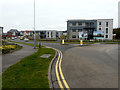
6
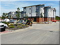
Progress of the development of land adjoining The Mayfly, Defiant Close
Compared with Image, the construction of the buildings is nearing completion. Planning permission has been approved, with conditions, by Folkestone and Hythe District Council under application number Y10/0739/SH for a “mixed used development comprising the erection of 4, three storey blocks providing 8 ground floor commercial units (Classes A1, A2, A3, B1 uses) and 48, two bedroom apartments above, together with associated access, parking, landscaping and open space”. The Mayfly refers to Image
Image: © John Baker
Taken: 18 Jun 2015
0.11 miles

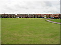
10

Post office store and community centre, Hawkinge
Image: © Nick Smith
Taken: 20 Jun 2008
0.12 miles