IMAGES TAKEN NEAR TO
Old Dover Road, FOLKESTONE, CT18 7HX
Introduction
This page details the photographs taken nearby to Old Dover Road, CT18 7HX by members of the Geograph project.
The Geograph project started in 2005 with the aim of publishing, organising and preserving representative images for every square kilometre of Great Britain, Ireland and the Isle of Man.

There are currently over 7.5m images from over14,400 individuals and you can help contribute to the project by visiting https://www.geograph.org.uk
Image Map
Images are licensed for reuse under creativecommons.org/licenses/by-sa/2.0
Notes
- Clicking on the map will re-center to the selected point.
- The higher the marker number, the further away the image location is from the centre of the postcode.
Image Listing (74 Images Found)
Images are licensed for reuse under creativecommons.org/licenses/by-sa/2.0
Image
Details
Distance
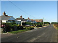
2
Old Dover Road
Chalet bungalows to the North side of the road.
Image: © Oast House Archive
Taken: 8 Apr 2010
0.02 miles
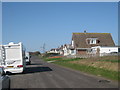
4
New Dover Road, Capel-le-Ferne
The hedge conceals a caravan park behind it
Image: © David Howard
Taken: 10 Apr 2016
0.05 miles
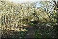
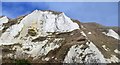
7
The cliffs of Folkestone Warren
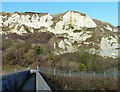
A zig-zag path descends the cliffs of Folkestone Warren beneath the Cliff Top Cafe. The path then follows the railway line eastwards before ascending rapidly again via steps to a caravan park. This view is about half way along, near the footbridge over the railway, and gives a close up of the chalk cliffs. The cliffs of Folkestone Warren consist of a series of landslides, and has probably been more intensively studied than any other landslide of comparable size in Great Britain. This is largely because it is crossed by the main Folkestone-Dover railway line, which on occasion has been displaced by slipping. This has created an immediate demand for detailed studies and monitoring. The site has suffered twelve major slips since 1765, and is now protected by complex coastal defence works.
Image: © Marathon
Taken: 8 Aug 2011
0.07 miles
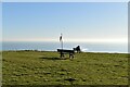
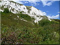
9
Cliffs above Folkestone Warren
This section of cliff suffered a major fall during the great land slip of 1915. Part of the Old Dover Road was subsequently diverted inland, accounting for the dog-leg now to be seen at the junction with Winehouse Lane.
Image: © Robin Webster
Taken: 16 Jan 2013
0.08 miles
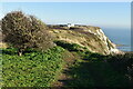
10
Folkestone Warren
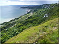
This photograph is taken looking along the cliffs at the eastern end of Folkestone Warren. Both the North Downs Way and the Saxon Shore Way follow the cliff top and give dramatic views of the chalk cliffs and of Folkestone Warren with the railway line at the bottom on which a train can be seen. In the distance is Folkestone and Folkestone Harbour, and far beyond on the horizon are the nuclear power stations at Dungeness. On this day, a number of heavy showers passed over Dungeness but then went out to sea from Folkestone. One can be seen in the distance here.
Image: © Marathon
Taken: 8 Aug 2011
0.09 miles