IMAGES TAKEN NEAR TO
Petrel Way, FOLKESTONE, CT18 7GY
Introduction
This page details the photographs taken nearby to Petrel Way, CT18 7GY by members of the Geograph project.
The Geograph project started in 2005 with the aim of publishing, organising and preserving representative images for every square kilometre of Great Britain, Ireland and the Isle of Man.

There are currently over 7.5m images from over14,400 individuals and you can help contribute to the project by visiting https://www.geograph.org.uk
Image Map
Images are licensed for reuse under creativecommons.org/licenses/by-sa/2.0
Notes
- Clicking on the map will re-center to the selected point.
- The higher the marker number, the further away the image location is from the centre of the postcode.
Image Listing (65 Images Found)
Images are licensed for reuse under creativecommons.org/licenses/by-sa/2.0
Image
Details
Distance
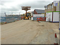
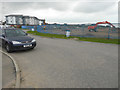
1
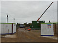
Building site entrance, Hurricane Way
Planning permission has been approved, with conditions, by Folkestone and Hythe District Council under application number 14/0341/SH for the “erection of 21 dwellings (class C3) together with associated access and landscaping”. The location was given as “land at Hurricane Way, Hawkinge, Kent”. A later view of the Image shows the progress of building construction beyond.
Image: © John Baker
Taken: 23 Oct 2015
0.11 miles
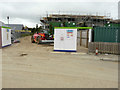
2
Building site entrance, Hurricane Way
Compared with Image, the erection of buildings beyond continues. Planning permission has been approved, with conditions, by Folkestone and Hythe District Council under application number 14/0341/SH for the “erection of 21 dwellings (class C3) together with associated access and landscaping”. The location was given as “land at Hurricane Way, Hawkinge, Kent”.
Image: © John Baker
Taken: 17 Feb 2016
0.11 miles
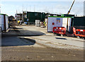
3
Building site entrance, Hurricane Way
Compared with Image, the erection of buildings beyond continues. Planning permission has been approved, with conditions, by Folkestone and Hythe District Council under application number 14/0341/SH for the “erection of 21 dwellings (class C3) together with associated access and landscaping”. The location was given as “land at Hurricane Way, Hawkinge, Kent”.
Image: © John Baker
Taken: 8 Jul 2016
0.11 miles
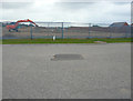
4
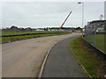
Looking south along Hurricane Way
The crane’s jib marks the location of the Image while the fencing, to the left of the road, marks the location of another building site. Planning permission has been approved, with conditions, by Folkestone and Hythe District Council under application number Y14/0336/SH for the “erection of retirement village (C2 use) providing 61 cottages, 50 apartments and associated 3 storey administrative building being details of access, appearance, landscaping, layout and scale pursuant to outline planning permission Y10/0738/SH”. The location was given as ‘’land at Hurricane Way, Hawkinge, Kent’’.
Image: © John Baker
Taken: 23 Oct 2015
0.12 miles
5
Construction of new houses, Hurricane Way
Planning permission has been approved, with conditions, by Folkestone and Hythe District Council under application number 14/0341/SH for the “erection of 21 dwellings (class C3) together with associated access and landscaping”. The location was given as “land at Hurricane Way, Hawkinge, Kent”. The builders were curious as to why I was taking photos but seemed reassured when I admitted to being a local.
Image: © John Baker
Taken: 8 Jul 2016
0.13 miles
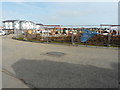
6

Site of retirement village, Hurricane Way
Planning permission has been approved, with conditions, by Folkestone and Hythe District Council under application number Y14/0336/SH for the “erection of retirement village (C2 use) providing 61 cottages, 50 apartments and associated 3 storey administrative building being details of access, appearance, landscaping, layout and scale pursuant to outline planning permission Y10/0738/SH”. A similar view of Image taken a few weeks ago.
Image: © John Baker
Taken: 24 Nov 2016
0.14 miles
7
Site of retirement village, Hurricane Way
Planning permission has been approved, with conditions, by Folkestone and Hythe District Council under application number Y14/0336/SH for the “erection of retirement village (C2 use) providing 61 cottages, 50 apartments and associated 3 storey administrative building being details of access, appearance, landscaping, layout and scale pursuant to outline planning permission Y10/0738/SH”. A similar view of Image taken a few weeks later.
Image: © John Baker
Taken: 7 Oct 2016
0.14 miles
8
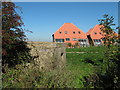
Pillbox near Gibraltar Lane
This bunker is a leftover from the World War II, in the background are (the hideous roofs) of a new housing development being built on the former Battle of Britain Airfield.
Image: © David Anstiss
Taken: 10 Oct 2010
0.14 miles
9
Site of retirement village, Hurricane Way
Planning permission has been approved, with conditions, by Folkestone and Hythe District Council under application number Y14/0336/SH for the “erection of retirement village (C2 use) providing 61 cottages, 50 apartments and associated 3 storey administrative building being details of access, appearance, landscaping, layout and scale pursuant to outline planning permission Y10/0738/SH”. The apartments of Terlingham Forum lie beyond the site. A similar view of Image taken a few weeks ago.
Image: © John Baker
Taken: 24 Nov 2016
0.15 miles
10
Site of retirement village, Hurricane Way
Planning permission has been approved, with conditions, by Folkestone and Hythe District Council under application number Y14/0336/SH for the “erection of retirement village (C2 use) providing 61 cottages, 50 apartments and associated 3 storey administrative building being details of access, appearance, landscaping, layout and scale pursuant to outline planning permission Y10/0738/SH”. A similar view of Image taken a few weeks later. The apartments of Terlingham Forum lie beyond the site.
Image: © John Baker
Taken: 7 Oct 2016
0.15 miles