IMAGES TAKEN NEAR TO
Mill Lane, FOLKESTONE, CT18 7BY
Introduction
This page details the photographs taken nearby to Mill Lane, CT18 7BY by members of the Geograph project.
The Geograph project started in 2005 with the aim of publishing, organising and preserving representative images for every square kilometre of Great Britain, Ireland and the Isle of Man.

There are currently over 7.5m images from over14,400 individuals and you can help contribute to the project by visiting https://www.geograph.org.uk
Image Map
Images are licensed for reuse under creativecommons.org/licenses/by-sa/2.0
Notes
- Clicking on the map will re-center to the selected point.
- The higher the marker number, the further away the image location is from the centre of the postcode.
Image Listing (36 Images Found)
Images are licensed for reuse under creativecommons.org/licenses/by-sa/2.0
Image
Details
Distance
1
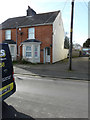
2, Mill Lane, Hawkinge
Planning permission has been approved, with conditions, by Folkestone and Hythe District Council under application number Y19/1289/FH for the “erection of single storey rear and side extension, a first floor rear extension, plus dormer window to attic and roof light. External cladding in grey fibre cement board. Re-submission of Y19/0969/FH”.
Image: © John Baker
Taken: 1 Mar 2020
0.03 miles
3
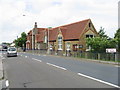
Hawkinge primary school
Taken from the car park of the village hall.
Image: © Nick Smith
Taken: 20 Jun 2008
0.07 miles
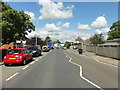
6
Looking NW along the old A260 Canterbury Road, Hawkinge
Image: © Nick Smith
Taken: 20 Jun 2008
0.08 miles
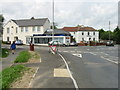
7

Hawkinge Village Sign
On small green in between Mill Lane and A260 Canterbury Road. Building on left is Nat West Bank. Sign with airforce symbol due to Battle of Britain Museum in Village. This sign is very easy to miss, very poorly placed.
Image: © David Anstiss
Taken: 31 Jan 2009
0.09 miles
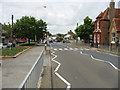
8
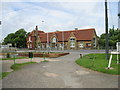
New road lay out on the old A260
The A260 Canterbury Road went straight through the middle of Hawkinge but a new road bypasses much of the old part of the village, this junction layout has changed as a consequence.
Image: © Nick Smith
Taken: 20 Jun 2008
0.09 miles
9
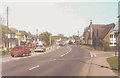
Canterbury Road, Hawkinge in 2001
As seen near to its junction with Mill Lane with Hawkinge county primary school just beyond, which opened on 2 June 1879.
Image: © John Baker
Taken: 22 May 2001
0.10 miles
10
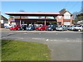
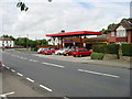
Radnor Garage, Canterbury Road
Radnor Garage was built for Lawrence Brisley by his brother David in 1932. Although it no longer sells either petrol or diesel for vehicles, the pumps are still there.
Image: © John Baker
Taken: 5 Apr 2015
0.10 miles