IMAGES TAKEN NEAR TO
Canterbury Road, FOLKESTONE, CT18 7BH
Introduction
This page details the photographs taken nearby to Canterbury Road, CT18 7BH by members of the Geograph project.
The Geograph project started in 2005 with the aim of publishing, organising and preserving representative images for every square kilometre of Great Britain, Ireland and the Isle of Man.

There are currently over 7.5m images from over14,400 individuals and you can help contribute to the project by visiting https://www.geograph.org.uk
Image Map
Images are licensed for reuse under creativecommons.org/licenses/by-sa/2.0
Notes
- Clicking on the map will re-center to the selected point.
- The higher the marker number, the further away the image location is from the centre of the postcode.
Image Listing (21 Images Found)
Images are licensed for reuse under creativecommons.org/licenses/by-sa/2.0
Image
Details
Distance
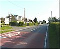
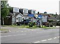
1
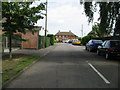
A260 Canterbury Road, Densole
Heading out of the village towards Canterbury.
Image: © Robin Webster
Taken: 29 Jun 2019
0.03 miles
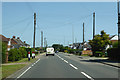
3
The northeast end of Densole
Looking along the A260/Canterbury Road in the direction of Swingfield Minnis
Image: © John Baker
Taken: 28 May 2012
0.03 miles
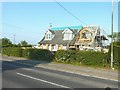
4
412, Canterbury Road
Planning permission has been approved, with conditions, by Folkestone and Hythe District Council under application number Y14/0715/SH for the “erection of a two storey side/rear extension together with extension and alteration to roof, other external alterations and formation of new access”. Beyond the house is number 414, which I photographed when it was undergoing a Image
Image: © John Baker
Taken: 5 Apr 2015
0.06 miles
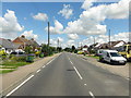
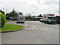
5
The northern approach of Densole
The board above the 40 mph road sign advertises the development that has taken place at Little Densole Farm. Access to this development is along the road to the right of the sign while on the other side is the house undergoing a Image
Image: © John Baker
Taken: 28 May 2012
0.06 miles
6
Roof conversion, 414 Canterbury Road, Densole
The work in this house was approved by Shepway District Council under application number Y11/0177/SH. It comprises the erection of a side and rear extension with accommodation in the roof-space and the extension of the existing hard surfacing.
Image: © John Baker
Taken: 28 May 2012
0.07 miles
7
Entrance to Black Horse Farm Caravan Club site
385 Canterbury Road, Densole
Image: © Nick Smith
Taken: 20 Jun 2008
0.09 miles
9
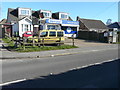
Densole News and Food, 382, Canterbury Road
Compared with Nick Smith’s Image, my image shows that the lawn at the front has been replaced with concrete to provide extra parking.
Image: © John Baker
Taken: 5 Apr 2015
0.12 miles