IMAGES TAKEN NEAR TO
Bulwark Street, DOVER, CT17 9TZ
Introduction
This page details the photographs taken nearby to Bulwark Street, CT17 9TZ by members of the Geograph project.
The Geograph project started in 2005 with the aim of publishing, organising and preserving representative images for every square kilometre of Great Britain, Ireland and the Isle of Man.

There are currently over 7.5m images from over14,400 individuals and you can help contribute to the project by visiting https://www.geograph.org.uk
Image Map
Images are licensed for reuse under creativecommons.org/licenses/by-sa/2.0
Notes
- Clicking on the map will re-center to the selected point.
- The higher the marker number, the further away the image location is from the centre of the postcode.
Image Listing (138 Images Found)
Images are licensed for reuse under creativecommons.org/licenses/by-sa/2.0
Image
Details
Distance
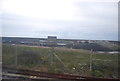
1
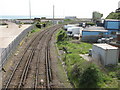
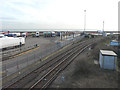
Railway to Folkestone
This railway line leads around the coast on the English Channel and leads to Folkestone. It is from Dover Priory Station.
Image: © David Anstiss
Taken: 2 May 2009
0.01 miles
2
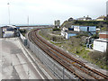
Temporary closure of the railway line
The line between Dover Priory and Folkestone Central stations is temporarily closed while repairs are being carried out to a section (seen here as Image which shows that there are no railway tracks, in situ, below Shakespeare Cliff) that was damaged in a storm on Christmas Eve 2015.
This view, taken from The Viaduct, shows that a no entry sign has been placed on the left hand track and a buffer stop on the right hand track, presumably to warn any train driver not to proceed any further.
According to SouthEastern Railway https://www.southeasternrailway.co.uk/ the line will remain closed until December 2016.
Image: © John Baker
Taken: 15 Apr 2016
0.03 miles
4
Bullwark Street
Seen from The Viaduct. The box-like blue building on the left belonged to Civil Rail Construction Ltd - it is 'to let'.
Image: © John Baker
Taken: 31 May 2013
0.03 miles
5
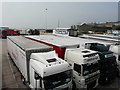
Looking southwest from The Viaduct
Over lorries parked in the freight clearance facility. Beyond them is a building advertising “hand truck wash”, which appeared in my Image but seen from another location.
Image: © John Baker
Taken: 24 Apr 2015
0.04 miles
6
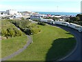
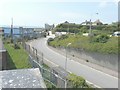
Lorries parked on Hawkesbury Street
I was standing on a bridge that carries Limekiln Street (A20) over this road. My position had been reached by following the path, seen here, and then climbing steps to gain access to Limekiln Street. Visibility was so good that the coast of France was visible and can be discerned through ‘larger sizes’.
Image: © John Baker
Taken: 5 Oct 2014
0.05 miles
7
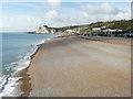
Shakespeare Beach from Admiralty Pier
Compared with Image, the pile of enormous lumps of granite has disappeared as they have been moved to protect the seawall at the far end of the beach, near to where the railway enters Shakespeare Tunnel in Image The beach was still closed to the public.
Image: © John Baker
Taken: 21 Oct 2016
0.05 miles
8
Erection of a building
Seen from The Viaduct, the building is located in the freight clearance & truck stop lorry park. The railway lines run between Dover Priory and Folkestone Central stations.
Image: © John Baker
Taken: 30 Jan 2015
0.05 miles
10
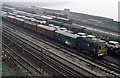
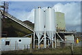
Dover Freight Yards
These yards were used for the marshalling of ferry wagons arriving and departing through Dover Western Docks. The yards became redundant with the advent of the Channel Tunnel and all the tracks have been lifted.
Image: © Martin Addison
Taken: Unknown
0.06 miles