IMAGES TAKEN NEAR TO
Channel View Road, DOVER, CT17 9TP
Introduction
This page details the photographs taken nearby to Channel View Road, CT17 9TP by members of the Geograph project.
The Geograph project started in 2005 with the aim of publishing, organising and preserving representative images for every square kilometre of Great Britain, Ireland and the Isle of Man.

There are currently over 7.5m images from over14,400 individuals and you can help contribute to the project by visiting https://www.geograph.org.uk
Image Map
Images are licensed for reuse under creativecommons.org/licenses/by-sa/2.0
Notes
- Clicking on the map will re-center to the selected point.
- The higher the marker number, the further away the image location is from the centre of the postcode.
Image Listing (228 Images Found)
Images are licensed for reuse under creativecommons.org/licenses/by-sa/2.0
Image
Details
Distance
1
Former branch of Folkestone Fixings
There are two notices on the main gate that read “we are sorry to say that this branch of Folkestone Fixings has now closed. Thank you for your custom over the last 4 years, but unfortunately our yard and buildings are needed by Dover Harbour Board as a result of major road changes taking place in Snargate Street to facilitate the expansion of the docks. We hope to see you in our ever expanding Folkestone branch or in one of our new branches to be opening soon or phone Folkestone 01303 222100”. The Folkestone branch is situated at CCK House, Park Farm Road, Park Farm Industrial Estate, Folkestone, Kent CT19 5EY in Image The company deals in timber and building supplies.
Image: © John Baker
Taken: 11 Oct 2013
0.06 miles
2

Shepway District : Kent Coastline & Dover Scenery
Looking down towards Dover and the harbour from a plane heading across to the continent.
Image: © Lewis Clarke
Taken: 23 Aug 2012
0.06 miles
3
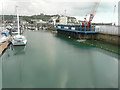
Construction site, quay beside Wellington Dock
Compared with Image, at last the reason for the construction of the blue walking gates has been revealed. They are to provide a new pedestrian and cyclist route, as the former Image and it is in use.
Planning permission was granted by Dover District Council under application number DOV/16/00308 for the “removal of part of quay wall to facilitate the creation of a new navigation channel between Wellington Dock and the Harbour and installation of a new retaining structure to close existing access between the Tidal Basin and Wellington Dock”.
Planning permission was also granted by Dover District Council, under application number DOV/16/01305, for the “modification of legal agreement (under S.106 of the Town and Country Planning Act 1990) to planning permission DOV/98/00334, to allow for the removal of 20 off-street residents parking spaces (to facilitate [a] navigational cut between Dover Harbour and Wellington Dock under the Dover Western Docks Revival Scheme).
More images of the construction site may be seen on http://www.doverforum.com/sea-news/
Image: © John Baker
Taken: 1 Sep 2017
0.06 miles
5
Former branch of Folkestone Fixings
There are two notices (just visible on the far right of the shot) on the main gate that read “we are sorry to say that this branch of Folkestone Fixings has now closed. Thank you for your custom over the last 4 years, but unfortunately our yard and buildings are needed by Dover Harbour Board as a result of major road changes taking place in Snargate Street to facilitate the expansion of the docks. We hope to see you in our ever expanding Folkestone branch or in one of our new branches to be opening soon or phone Folkestone 01303 222100”. The Folkestone branch is situated at CCK House, Park Farm Road, Park Farm Industrial Estate, Folkestone, Kent CT19 5EY in Image The company deals in timber and building supplies.
Image: © John Baker
Taken: 11 Oct 2013
0.07 miles
6
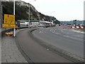
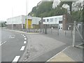
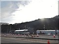
Roadworks on the A20
The roadworks started on 20 February 2016 and are expected to last 52 weeks. The Prince of Wales and York Street roundabouts are to be replaced by traffic lights. This view is of part of Limekiln roundabout, which is not included in the scheme but provides a means of access for those drivers who wish to head towards York Street roundabout from Union Street and, as the road sign indicates, access to the Cruise Terminal and freight clearance facility.
Image: © John Baker
Taken: 26 Feb 2016
0.08 miles
7
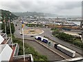
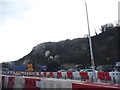
The A20 in Dover
Looking east towards Dover eastern docks.
Image: © Andrew Abbott
Taken: 10 Jun 2019
0.08 miles
8
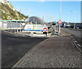
Changes at Dover South Service Station, Limekiln Street
Planning permission has been granted by Dover District Council under application number DOV/15/00427 for the “erection of four jetwash bays (existing bays to be demolished), creation of two valet bays and fifteen parking spaces”. The service station is owned by BP.
Image: © John Baker
Taken: 8 Jan 2016
0.08 miles
9
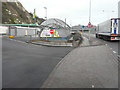
Dover South Service Station, Limekiln Street
Compared with Image, the erection of four new jetwash bays has been completed and they are in operation. The service station is owned by BP.
Image: © John Baker
Taken: 29 Jan 2016
0.08 miles
10
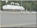
Cliffs by the A20, Dover
The building on the left is a Subway and the rest is part of a garage
Image: © David Howard
Taken: 10 Apr 2016
0.08 miles