IMAGES TAKEN NEAR TO
Markland Road, DOVER, CT17 9NL
Introduction
This page details the photographs taken nearby to Markland Road, CT17 9NL by members of the Geograph project.
The Geograph project started in 2005 with the aim of publishing, organising and preserving representative images for every square kilometre of Great Britain, Ireland and the Isle of Man.

There are currently over 7.5m images from over14,400 individuals and you can help contribute to the project by visiting https://www.geograph.org.uk
Image Map
Images are licensed for reuse under creativecommons.org/licenses/by-sa/2.0
Notes
- Clicking on the map will re-center to the selected point.
- The higher the marker number, the further away the image location is from the centre of the postcode.
Image Listing (9 Images Found)
Images are licensed for reuse under creativecommons.org/licenses/by-sa/2.0
Image
Details
Distance
1
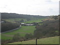
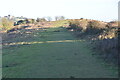
Elm Vale Recreational Ground
As seen from Whinless Down. This large recreational ground is beside Elm Vale Road. In the background is Harbour School. Elms Wood is on the left.
Image: © David Anstiss
Taken: 27 Feb 2011
0.08 miles
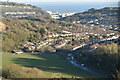
3
Elms Vale Road
North Downs to rear.
Image: © Oast House Archive
Taken: 17 Jul 2010
0.11 miles
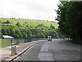
5

Footpath on Whinless Down (3)
A path leads from Long Wood along a ridge beside the open access land on the right. The path leads towards Noah's Ark Road in Dover.
Image: © David Anstiss
Taken: 27 Feb 2011
0.23 miles
6
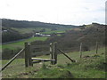
Stile to Whinless Down open access land
A footpath leads from Noah's Ark Road towards Long Wood along a ridge. The stile on the left is one of many entrances to the open land on the valley side.
In the background is Harbour School and playing fields on Elms Vale Road.
Image: © David Anstiss
Taken: 27 Feb 2011
0.23 miles
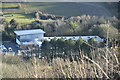
8
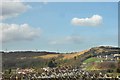
Whinless Down, Dover
The name of Whinless Down is not a derivation of "windless" - in fact the spot is very exposed. It comes from the Middle English word "whynne" meaning gorse and signifies that it is the only place in the area where the gorse will not grow.
Image: © John Mavin
Taken: 26 Feb 2008
0.24 miles
9
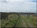
Footpath on Whinless Down (4)
A path leads from Noah's Ark Road, along a ridge. On the left is a large piece of open access ground / nature reserve on the valley side. On the right is a couple of horse paddocks.
In the background is Long Wood.
Image: © David Anstiss
Taken: 27 Feb 2011
0.24 miles