IMAGES TAKEN NEAR TO
Citadel Heights, DOVER, CT17 9DS
Introduction
This page details the photographs taken nearby to Citadel Heights, CT17 9DS by members of the Geograph project.
The Geograph project started in 2005 with the aim of publishing, organising and preserving representative images for every square kilometre of Great Britain, Ireland and the Isle of Man.

There are currently over 7.5m images from over14,400 individuals and you can help contribute to the project by visiting https://www.geograph.org.uk
Image Map (Loading...)


Getting Data...Please wait
Leaflet Map data © OpenStreetMap
Images are licensed for reuse under creativecommons.org/licenses/by-sa/2.0
Notes
- Clicking on the map will re-center to the selected point.
- The higher the marker number, the further away the image location is from the centre of the postcode.
Image Listing (36 Images Found)
Images are licensed for reuse under creativecommons.org/licenses/by-sa/2.0
Image
Details
Distance
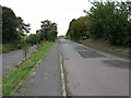
1
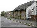
Dover Borstal Officer Recreation Club
On Citadel Road, the borstal has now become the immigration removal centre.
Image: © Nick Smith
Taken: 14 Oct 2009
0.06 miles
2
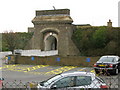
Entrance to the Citadel, the immigration removal centre
Formerly the borstal but now run as a removal centre for illegal immigrants.
Image: © Nick Smith
Taken: 14 Oct 2009
0.08 miles
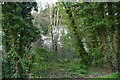
3
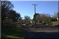
Citadel Road
The North Downs Way path goes off to the left here.
Image: © Robert Eva
Taken: 20 Jan 2017
0.13 miles
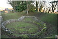
4
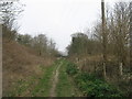
Track in Western Heights
The North Downs Way and Saxon Shore Way (long distance paths) leads from King's Ropewalk in Aycliff, through a local nature reserve on the hills between Aycliff and Maxton, towards South Military Road.
Image: © David Anstiss
Taken: 20 Mar 2011
0.13 miles

7
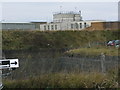
Part of the immigration removal centre on Western Heights
Formerly the borstal but now run by as a removal centre for illegal immigrants.
Image: © Nick Smith
Taken: 14 Oct 2009
0.13 miles
9
View along Citadel Road and Western Close
Western Close is the left hand road.
Image: © Nick Smith
Taken: 14 Oct 2009
0.14 miles
10
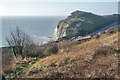
Saxon Shore Way / NDW, and A20
The footpath in the foreground is part of the Saxon Shore Way, also the North Downs Way. Behind is the main road of the area, the A20 from Dover. Behind that is Shakespeare Cliff.
Image: © Andy Stephenson
Taken: 17 Jan 2010
0.14 miles