IMAGES TAKEN NEAR TO
Snargate Street, DOVER, CT17 9BZ
Introduction
This page details the photographs taken nearby to Snargate Street, CT17 9BZ by members of the Geograph project.
The Geograph project started in 2005 with the aim of publishing, organising and preserving representative images for every square kilometre of Great Britain, Ireland and the Isle of Man.

There are currently over 7.5m images from over14,400 individuals and you can help contribute to the project by visiting https://www.geograph.org.uk
Image Map
Images are licensed for reuse under creativecommons.org/licenses/by-sa/2.0
Notes
- Clicking on the map will re-center to the selected point.
- The higher the marker number, the further away the image location is from the centre of the postcode.
Image Listing (1510 Images Found)
Images are licensed for reuse under creativecommons.org/licenses/by-sa/2.0
Image
Details
Distance
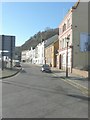
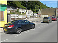
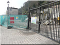
2
Snargate St
A small street running parallel to the A20.
Image: © N Chadwick
Taken: 28 Aug 2011
0.01 miles
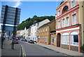
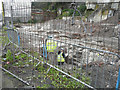
3
Demolition site, Snargate Street
"Demolition site, keep out" was the wording on the notices attached to the fence. The demolition must have taken place some time ago as large buddleias had established themselves on the site.
Image: © John Baker
Taken: 31 May 2013
0.01 miles
4
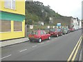
149-156 Snargate Street
Planning permission has been granted by Dover District Council under application number DOV/13/00478 for an “outline application with all matters reserved for the erection of 9 dwellings”. When built, the houses will be marketed by Andrew Scott Robinson http://www.as-r.co.uk/ whose “for sale” board is on display in this view. Little has changed in the overall appearance of the site since I took the Image
Image: © John Baker
Taken: 25 Oct 2013
0.01 miles
5
149-156, Snargate Street
Compared with Image, during the intervening years the site became overgrown with buddleia bushes, but these have now been removed and also the yellow safety netting. A planning notice has been attached to the lamppost. Subsequently, Planning permission was granted by Dover District Council under application number DOV/13/00478 for an “outline application with all matters reserved for the erection of 9 dwellings”.
Image: © John Baker
Taken: 11 Sep 2015
0.01 miles
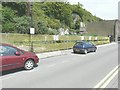
6
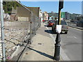
Looking northeast along, Snargate Street
There is a planning notice attached to the lamppost. Subsequently, planning permission was granted by Dover District Council under application number DOV/13/00478 for an “outline application with all matters reserved for the erection of 9 dwellings”. It relates to the derelict site on the left, which used to be where houses, bearing the numbers 149-156, stood.
Image: © John Baker
Taken: 11 Sep 2015
0.01 miles
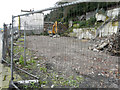
7
Archaeological dig at 149-156, Snargate Street
Compared with Image, the dig has advanced to a deeper level. The site is eventually to be used for housing. Planning permission has been granted by Dover District Council under application number DOV/13/00478 for an “outline application with all matters reserved for the erection of 9 dwellings”.
Image: © John Baker
Taken: 29 Jan 2016
0.01 miles
8
Derelict site, 149-156, Snargate Street
Compared with Image, the dig has been covered with soil. The site is eventually to be used for housing. Planning permission has been granted by Dover District Council under application number DOV/13/00478 for an “outline application with all matters reserved for the erection of 9 dwellings”.
Image: © John Baker
Taken: 5 Feb 2016
0.01 miles
9
Construction site, 149-156, Snargate Street
Compared with Image, the footpath has been closed to pedestrians, as the fence has been extended across it, while an exploratory derrick has been erected inside the fence. The site will eventually be used for housing. Planning permission has been granted by Dover District Council under application number DOV/13/00478 for “outline application with all matters reserved for the erection of 9 dwellings”.
Image: © John Baker
Taken: 11 Mar 2016
0.01 miles
10
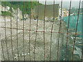
Construction site, 149-156, Snargate Street
Compared with Image although seen through safety netting, from the other direction, work has commenced on the foundations of the dwellings. Planning permission has been granted by Dover District Council under application number DOV/13/00478 for an “outline application with all matters reserved for the erection of 9 dwellings”.
Image: © John Baker
Taken: 17 Jun 2016
0.01 miles