IMAGES TAKEN NEAR TO
Lister Close, DOVER, CT17 0TP
Introduction
This page details the photographs taken nearby to Lister Close, CT17 0TP by members of the Geograph project.
The Geograph project started in 2005 with the aim of publishing, organising and preserving representative images for every square kilometre of Great Britain, Ireland and the Isle of Man.

There are currently over 7.5m images from over14,400 individuals and you can help contribute to the project by visiting https://www.geograph.org.uk
Image Map
Images are licensed for reuse under creativecommons.org/licenses/by-sa/2.0
Notes
- Clicking on the map will re-center to the selected point.
- The higher the marker number, the further away the image location is from the centre of the postcode.
Image Listing (141 Images Found)
Images are licensed for reuse under creativecommons.org/licenses/by-sa/2.0
Image
Details
Distance
1
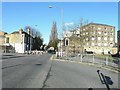
London Road, Buckland, Dover
At its junction with Coombe Valley Road. Only the right hand carriageway of the road ahead was open to traffic as the left hand carriageway was cordoned off due to the laying of replacement sewer and gas mains. The converted mill building lies in Lorne Road.
Image: © John Baker
Taken: 8 Feb 2011
0.02 miles
2
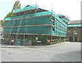
Charles Lister Court, Lister Close
As viewed from St Radigund's Road, Charles Lister Court (seen here undergoing renovation) has a total of 53 sheltered accommodation flats http://www.housingcare.org/housing-care/facility-info-6197-charles-lister-court-dover-england.aspx
Image: © John Baker
Taken: 31 May 2013
0.02 miles
3
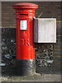
Dover: unusual Victorian/George V postbox in St. Radigund?s Road
This is a particularly unusual postbox, as the main body is Victorian (or possibly from the early years of Edward VII), while the door is from the reign of George V, as clearly denoted by his GR cipher.
The telltale sign is the fact that the door is not full-height. Victorian and early Edward VII boxes had the slot in this position, flanked by the words POST and OFFICE, above the top of the door. Midway through Edward VII's reign, the design was modified so that the door was full-height, incorporating the slot within it. This prevented posted items from getting stuck in the top of the box.
It is therefore the case that the GR door is nonstandard; by the time of George V a short door would have no reason to be in ordinary supply.
The GR cipher and keyhole are also higher than on a standard George V box, almost reaching the information plate. Compare with examples of the two standard layouts:
Image] (top half of crown level with keyhole)
Image] (tip of crown level with keyhole)
The absence of the standard POST OFFICE below the cipher is also notable, and also the absence of the door-pull which is standard on George V boxes.
Attached to the box, and arguably not enhancing its appearance, is a modern fibreglass pouch box or drop box - see below.
Image: © Chris Downer
Taken: 27 Feb 2016
0.02 miles
4
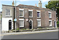
226-228, London Road
This terrace of houses is grade II listed and dates from the early 19th century
https://www.britishlistedbuildings.co.uk/101343827-226-227-and-228-london-road-dover#.W0EV2f6Wzcd
Image: © John Baker
Taken: 15 Jun 2018
0.03 miles
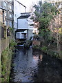
5
River Dour
The Old Mill, now converted into apartments, stands beside the mill race, which used to power it when it was a working mill.
Image: © John Baker
Taken: 15 Jun 2018
0.03 miles
6
Rhyder House, London Road
A former care home now with boarded up windows and an air of neglect.
Image: © John Baker
Taken: 22 May 2015
0.03 miles
7
Lundy House, London Road
When it was a care home, it was named Image
Image: © John Baker
Taken: 16 Apr 2021
0.03 miles
8

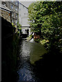
River Dour
As seen from Lorne Road bridge over the river.
Image: © David Anstiss
Taken: 6 Mar 2011
0.03 miles
9
Lower Buckland Corn Mill, Buckland
By the River Dour, converted in 1996 to apartments, viewed from the bridge on Lorne Road.
Image: © pam fray
Taken: 4 Dec 2018
0.04 miles
10
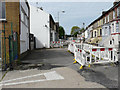
Laying a gas main along Coombe Valley Road
Coombe Valley Road is to the left of the view of Image The work had started on 30 March 2015 and was expected to last for 15 weeks.
Image: © John Baker
Taken: 22 May 2015
0.05 miles