IMAGES TAKEN NEAR TO
Bunkers Hill Road, DOVER, CT17 0JJ
Introduction
This page details the photographs taken nearby to Bunkers Hill Road, CT17 0JJ by members of the Geograph project.
The Geograph project started in 2005 with the aim of publishing, organising and preserving representative images for every square kilometre of Great Britain, Ireland and the Isle of Man.

There are currently over 7.5m images from over14,400 individuals and you can help contribute to the project by visiting https://www.geograph.org.uk
Image Map
Images are licensed for reuse under creativecommons.org/licenses/by-sa/2.0
Notes
- Clicking on the map will re-center to the selected point.
- The higher the marker number, the further away the image location is from the centre of the postcode.
Image Listing (112 Images Found)
Images are licensed for reuse under creativecommons.org/licenses/by-sa/2.0
Image
Details
Distance
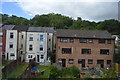
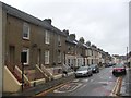
4
14-16, Primrose Road
Planning permission has been granted by Dover District Council under application number DOV/20/00162 for an “outline application for the erection of 4 dwellings with associated access and parking with (all matters reserved) (existing dwellings to be demolished)”.
Image: © John Baker
Taken: 18 Jul 2020
0.14 miles
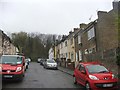
6

14-16, Primrose Road
Viewed from Coombe Valley Road, planning permission has been granted by Dover District Council under application number DOV/20/00162 for an “outline application for the erection of 4 dwellings with associated access and parking with (all matters reserved) (existing dwellings to be demolished)”.
Image: © John Baker
Taken: 18 Jul 2020
0.15 miles
7
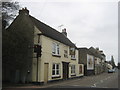
The Bull Public House, Dover
Near the end of the A256 London Road.
Image: © David Anstiss
Taken: 6 Mar 2011
0.15 miles
8

Lychgate to Parish Church of St Andrew Buckland
As seen from Crabble Meadows.
Image: © David Anstiss
Taken: 6 Mar 2011
0.15 miles
9

Parish Church of St Andrew Buckland
As seen from Crabble Meadows path.
Image: © David Anstiss
Taken: 6 Mar 2011
0.16 miles
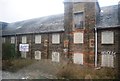
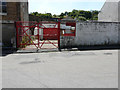
10
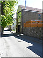
The Old Forge, Bunker?s Hill
This was Image in March 2018.
Image: © John Baker
Taken: 12 May 2019
0.16 miles