IMAGES TAKEN NEAR TO
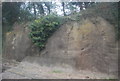
Hillside Road, DOVER, CT17 0JG
Introduction
This page details the photographs taken nearby to Hillside Road, CT17 0JG by members of the Geograph project.
The Geograph project started in 2005 with the aim of publishing, organising and preserving representative images for every square kilometre of Great Britain, Ireland and the Isle of Man.

There are currently over 7.5m images from over14,400 individuals and you can help contribute to the project by visiting https://www.geograph.org.uk
Image Map
Images are licensed for reuse under creativecommons.org/licenses/by-sa/2.0
Notes
- Clicking on the map will re-center to the selected point.
- The higher the marker number, the further away the image location is from the centre of the postcode.
Image Listing (117 Images Found)
Images are licensed for reuse under creativecommons.org/licenses/by-sa/2.0
Image
Details
Distance
1

The line to Canterbury at Buckland Junction
Image: © N Chadwick
Taken: 15 Feb 2018
0.03 miles
2
Wall by the railway line
This is where the line to Deal and Sandwich diverts off the line to Canterbury.
Image: © N Chadwick
Taken: 5 Apr 2012
0.04 miles
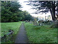
3
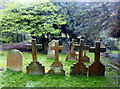
Gravestone in St. Andrew's churchyard, Buckland-in-Dover
They seem to belong to members of the Fielding family, including one marking the grave of the Rev. Charles Fielding, died 1866 aged 75.
Image: © pam fray
Taken: 4 Dec 2018
0.05 miles
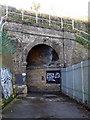
4
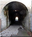
Crabble Meadows railway tunnel, Buckland
The tunnel links Crabble Meadows with Crabble Avenue and Hillside Road.
Image: © pam fray
Taken: 4 Dec 2018
0.05 miles
5
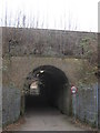
Subway under the railway near Crabble Avenue
This long subway tunnel leads under the two railway lines heading into Dover (from Canterbury and Deal). The foot tunnel leads to Crabble Meadows beside the Parish Church of St.Andrew, Buckland.
Image: © David Anstiss
Taken: 6 Mar 2011
0.07 miles
7
Crabble Meadows railway tunnel, Buckland
The tunnel links Crabble Meadows with Crabble Avenue and Hillside Road.
Image: © pam fray
Taken: 4 Dec 2018
0.07 miles
8

Crabble Meadows
This path leads from Crabble Avenue ( via Image ), past a cemetery beside St.Andrews Church towards the A256 Crabble Hill.
Image: © David Anstiss
Taken: 6 Mar 2011
0.08 miles
9
Churchyard of St Andrew's Church, Buckland-in-Dover
The parish church was built in 1196 but Saxon origins can still be seen. Partially rebuilt and enlarged in 1851 and further extended in 1880. The large churchyard runs beside Crabble Meadows.
Image: © pam fray
Taken: 4 Dec 2018
0.08 miles
10

Entrance to Crabble Recreational Ground
As seen from Crabble Avenue. This leads to two large sports grounds and recreational area around them.
Image: © David Anstiss
Taken: 6 Mar 2011
0.10 miles