IMAGES TAKEN NEAR TO
Poulton Close, DOVER, CT17 0HL
Introduction
This page details the photographs taken nearby to Poulton Close, CT17 0HL by members of the Geograph project.
The Geograph project started in 2005 with the aim of publishing, organising and preserving representative images for every square kilometre of Great Britain, Ireland and the Isle of Man.

There are currently over 7.5m images from over14,400 individuals and you can help contribute to the project by visiting https://www.geograph.org.uk
Image Map
Images are licensed for reuse under creativecommons.org/licenses/by-sa/2.0
Notes
- Clicking on the map will re-center to the selected point.
- The higher the marker number, the further away the image location is from the centre of the postcode.
Image Listing (20 Images Found)
Images are licensed for reuse under creativecommons.org/licenses/by-sa/2.0
Image
Details
Distance
1
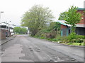
Looking W along Poulton Close
A fairly typical industrial estate road.
Image: © Nick Smith
Taken: 29 Apr 2007
0.06 miles
2
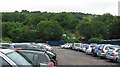
Car park, Coombe Valley Industrial Estate
An area of land used for long term parking in an industrial estate. Gorse Hill in the background.
Image: © Richard Webb
Taken: 13 Jul 2010
0.10 miles
3
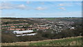
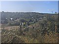
View of St. Radigunds, Dover
As seen from the footpath on Whinless Down.
Looking towards an estate, housing area of Dover. In the foreground some works buildings on Poulton Road. Coombe Down is on the other side of the valley.
Image: © David Anstiss
Taken: 27 Feb 2011
0.12 miles
4
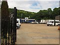
Relyon car park
Long term parking for ferry passengers.
Image: © Richard Webb
Taken: 7 Jul 2010
0.15 miles
5
St Radigund's part of Dover
Foot path gate to Coombe Down on the edges of Dover.
https://en.wikipedia.org/wiki/Dover
Image: © James Emmans
Taken: 13 Sep 2020
0.15 miles
6
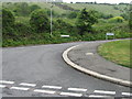
Junction of St Radigund's Road with Barwick Road
Image: © Nick Smith
Taken: 29 Apr 2007
0.15 miles
7

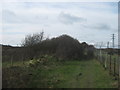
Footpath on Whinless Down (3)
A path leads from Long Wood along a ridge beside the open access land on the right. The path leads towards Noah's Ark Road in Dover.
Image: © David Anstiss
Taken: 27 Feb 2011
0.15 miles
8
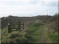
Kissing gate on Whinless Down
A footpath leads from Noah's Ark Road towards Long Wood, it follows a ridge beside the open access land / nature reserve on the left. The kissing gate is one of many entrances.
Image: © David Anstiss
Taken: 27 Feb 2011
0.16 miles
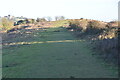
10
Footpath on Whinless Down (2)
This path leads from Noah's Ark Road towards Long Wood, it follows a ridge beside the open access land / nature reserve on the left.
Image: © David Anstiss
Taken: 27 Feb 2011
0.16 miles