IMAGES TAKEN NEAR TO
Primrose Road, DOVER, CT17 0FP
Introduction
This page details the photographs taken nearby to Primrose Road, CT17 0FP by members of the Geograph project.
The Geograph project started in 2005 with the aim of publishing, organising and preserving representative images for every square kilometre of Great Britain, Ireland and the Isle of Man.

There are currently over 7.5m images from over14,400 individuals and you can help contribute to the project by visiting https://www.geograph.org.uk
Image Map
Images are licensed for reuse under creativecommons.org/licenses/by-sa/2.0
Notes
- Clicking on the map will re-center to the selected point.
- The higher the marker number, the further away the image location is from the centre of the postcode.
Image Listing (69 Images Found)
Images are licensed for reuse under creativecommons.org/licenses/by-sa/2.0
Image
Details
Distance
1
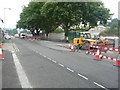
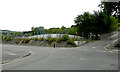
Coombe Valley Road
Four plane trees overlook a building site, (to be known as Rosewood Heights and was once the location of a firm called Barwick). Planning permission has been granted by Dover District Council under application number DOV/13/00261 for the “erection of 24 dwellings, construction of vehicular access and associated car parking (existing buildings to be demolished)”.
Image: © John Baker
Taken: 19 Aug 2016
0.03 miles
2
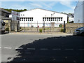
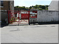
14-16, Primrose Road
Viewed from Coombe Valley Road, planning permission has been granted by Dover District Council under application number DOV/20/00162 for an “outline application for the erection of 4 dwellings with associated access and parking with (all matters reserved) (existing dwellings to be demolished)”.
Image: © John Baker
Taken: 18 Jul 2020
0.03 miles
3
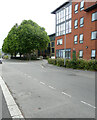
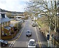
Coombe Valley Road
The red brick building is a care home called Willow Park Lodge and the block of flats beyond is called Rosewood Heights..
This was Image during the construction of Rosewood Heights.
Image: © John Baker
Taken: 31 Jul 2021
0.04 miles
4
Building site, Coombe Valley Road
The development (to be known as Rosewood Heights) is being constructed on the site of a firm called Barwick. Planning permission has been granted by Dover District Council under application number DOV/13/00261 for the “erection of 24 dwellings, construction of vehicular access and associated car parking (existing buildings to be demolished)”.
Image: © John Baker
Taken: 19 Aug 2016
0.04 miles
5
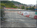
Redundant gasholder, Coombe Valley Road
Planning permission has been granted by Dover District Council under application number DOV/21/01050 for “prior approval (which was approved) for the demolition and dismantling of redundant gasholder station”.
Image: © John Baker
Taken: 31 Jul 2021
0.05 miles
6
14-16, Primrose Road
Planning permission has been granted by Dover District Council under application number DOV/20/00162 for an “outline application for the erection of 4 dwellings with associated access and parking with (all matters reserved) (existing dwellings to be demolished)”.
Image: © John Baker
Taken: 18 Jul 2020
0.05 miles
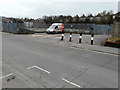
7
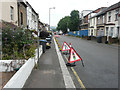
Looking east-northeast along Coombe Valley Road
The building that is under construction, behind the hoarding, is being built on the site of Powell Print. Planning permission has been granted by Dover District Council under application number DOV/14/00910 for a “reserved matters application for the erection of a care home (use class C2) and creation of access (existing building to be demolished); (details pursuant to DOV/13/00952: the outline application for the erection of a care home (use class C2), creation of a vehicular access and associated landscaping (existing buildings to be demolished))”. The traffic control was causing long delays for drivers.
Image: © John Baker
Taken: 19 Aug 2016
0.08 miles
10
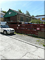
Depot, Masons Road
Planning permission has been granted by Dover District Council under application number DOV/
20/00102 for the “erection of 2 semi-detached dwellings and associated parking (existing building to be demolished) (amended plans)”.
Image: © John Baker
Taken: 18 Jul 2020
0.10 miles