IMAGES TAKEN NEAR TO
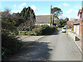
The Drove, DOVER, CT16 3JB
Introduction
This page details the photographs taken nearby to The Drove, CT16 3JB by members of the Geograph project.
The Geograph project started in 2005 with the aim of publishing, organising and preserving representative images for every square kilometre of Great Britain, Ireland and the Isle of Man.

There are currently over 7.5m images from over14,400 individuals and you can help contribute to the project by visiting https://www.geograph.org.uk
Image Map
Images are licensed for reuse under creativecommons.org/licenses/by-sa/2.0
Notes
- Clicking on the map will re-center to the selected point.
- The higher the marker number, the further away the image location is from the centre of the postcode.
Image Listing (32 Images Found)
Images are licensed for reuse under creativecommons.org/licenses/by-sa/2.0
Image
Details
Distance
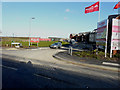
1
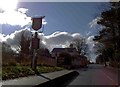
Roll up reduced price for the Royal Oak
Recession strikes on Sandwich Road Whitfield, Dover.
Image: © Steve Fareham
Taken: 5 Mar 2009
0.06 miles
2
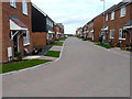
Arable Road
This is on the housing estate called Bowmans Place.
Image: © John Baker
Taken: 20 Aug 2017
0.06 miles
3
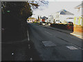
Looking north-northeast along Sandwich Road
In the distance, just beyond two trees on the right, is a new housing estate, still under construction, called Bowmans Place. Planning permission has been granted by Dover District Council under application number DOV/13/00607 for a “reserved matters application for 74 dwellings (landscaping, access, scale, layout and appearance) details pursuant to outline permission DOV/10/1011 phase 1A (amended details)”. The location is described as Site at Phase 1A - Whitfield Urban Extension.
Image: © John Baker
Taken: 16 Feb 2016
0.07 miles
4
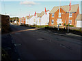
Looking north-northeast along Sandwich Road
The newly built houses are part of a new housing estate, still under construction, called Bowmans Place. Planning permission has been granted by Dover District Council under application number DOV/13/00607 for a “reserved matters application for 74 dwellings (landscaping, access, scale, layout and appearance) details pursuant to outline permission DOV/10/1011 phase 1A (amended details)”. The location is described as Site at Phase 1A - Whitfield Urban Extension.
Image: © John Baker
Taken: 16 Feb 2016
0.07 miles
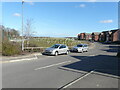
5
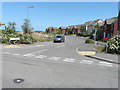
Field View Road
The mound of earth, to the left of the car, may have been excavated from the site of the Image; it has spoiled the appearance of the former verge of Image
Image: © John Baker
Taken: 28 Jun 2020
0.09 miles
6
Field Road View
All traces of Abbey’s advertising boards have disappeared from the entrance to Image on the housing estate called Bowmans Place.
Image: © John Baker
Taken: 20 Aug 2017
0.10 miles
7
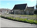
Whitfield United Reformed Church, Chapel Road
Viewed from Forge Lane, planning permission has been granted by Dover District Council under application number DOV/20/00851 for the “erection of three dwellings with associated access (existing church to be demolished)”.
This is the eastern side of Image
Image: © John Baker
Taken: 6 Mar 2021
0.10 miles
8
Field View Road
The road leads into a new housing estate, still under construction, called Bowmans Place. Planning permission has been granted by Dover District Council under application number DOV/13/00607 for “reserved matters application for 74 dwellings (landscaping, access, scale, layout and appearance) details pursuant to outline permission DOV/10/1011 phase 1A (amended details)”. The location is described as Site at Phase 1A - Whitfield Urban Extension.
Image: © John Baker
Taken: 16 Feb 2016
0.10 miles
9
Whitfield United Reformed Church, Chapel Road
Planning permission has been granted by Dover District Council under application number DOV/20/00851 for the “erection of three dwellings with associated access (existing church to be demolished)”.
This is the western side of Image
Image: © John Baker
Taken: 6 Mar 2021
0.10 miles
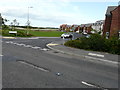
10
Field View Road
The mound of earth in the view of Image has been planted with sapling trees, protected by tuley tubes.
Image: © John Baker
Taken: 6 Mar 2021
0.10 miles