IMAGES TAKEN NEAR TO
Buckland Avenue, DOVER, CT16 2NT
Introduction
This page details the photographs taken nearby to Buckland Avenue, CT16 2NT by members of the Geograph project.
The Geograph project started in 2005 with the aim of publishing, organising and preserving representative images for every square kilometre of Great Britain, Ireland and the Isle of Man.

There are currently over 7.5m images from over14,400 individuals and you can help contribute to the project by visiting https://www.geograph.org.uk
Image Map
Images are licensed for reuse under creativecommons.org/licenses/by-sa/2.0
Notes
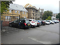
- Clicking on the map will re-center to the selected point.
- The higher the marker number, the further away the image location is from the centre of the postcode.
Image Listing (124 Images Found)
Images are licensed for reuse under creativecommons.org/licenses/by-sa/2.0
Image
Details
Distance
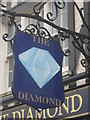
1
The Diamond Public House, Dover
On Heathfield Avenue.
Image: © David Anstiss
Taken: 6 Mar 2011
0.02 miles
4
Former Factory Site, Lorne Road
Planning permission has been granted by Dover District Council under application number DOV/16/00792 for the “change of use to a mixed use B2/B8 (micro brewer) with ancillary A4 (drinking establishment) use (amended description)”.
Image: © John Baker
Taken: 16 Sep 2016
0.09 miles
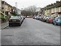
5
Looking east across a carpark, Lorne Road
Planning permission has been granted by Dover District Council under application number DOV/10/01132 for the “erection of 5 dwellings, a detached building containing 7 self-contained flats, construction of access and associated parking and landscaping”. The location was described as former car sales site, St Martin’s Yard, east side, Lorne Road.
Image: © John Baker
Taken: 16 Sep 2016
0.10 miles
6
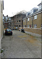
Erection of flats, St Martin?s Yard, Lorne Road
Planning permission has been granted by Dover District Council under application number DOV/10/01132 for the “erection of 5 dwellings, a detached building containing 7 self-contained flats, construction of access and associated parking and landscaping”. The location was described as former car sales site, St Martin’s Yard, east side, Lorne Road. The building, at the far end of the yard, is the detached building containing 7 self-contained flats, which is referred to in the application. The building can also be seen when Image
This image shows these Image after building work had been completed.
Image: © John Baker
Taken: 21 Oct 2016
0.10 miles
7
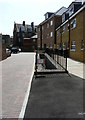
Flats, St Martin?s Yard, Lorne Road
This image shows Image
Image: © John Baker
Taken: 15 Jun 2018
0.10 miles
8
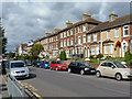
Houses on Barton Road, Dover
A continuous terrace all to the same basic design and in the same decorative brickwork, except where later rendered. Part way along an odd decision was made to increase the height by a storey.
Image: © Robin Webster
Taken: 26 Sep 2015
0.10 miles
9
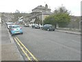
Looking north-northeast along Cherry Tree Avenue
Work is being carried out to the former White Cliffs Medical Centre (the building that is shrouded in scaffolding). Planning permission has been granted by Dover District Council under application number DOV/13/00211 for a “change of use and conversion to a single residential dwelling”. The railings, between the parked car and the right side of the frame, mark where the River Dour passes under the road.
Image: © John Baker
Taken: 28 Dec 2013
0.10 miles
10
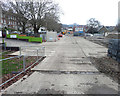
Barton County Primary School, Barton Road
Seen from Cherry Tree Avenue, planning permission has been granted by Dover District Council under application number DOV/18/00424 for the “erection of a two storey junior school building and demolition of 2 existing school buildings”.
This was Image after the construction work had been completed.
Image: © John Baker
Taken: 5 Jan 2019
0.10 miles