IMAGES TAKEN NEAR TO
Harold Street, DOVER, CT16 1SU
Introduction
This page details the photographs taken nearby to Harold Street, CT16 1SU by members of the Geograph project.
The Geograph project started in 2005 with the aim of publishing, organising and preserving representative images for every square kilometre of Great Britain, Ireland and the Isle of Man.

There are currently over 7.5m images from over14,400 individuals and you can help contribute to the project by visiting https://www.geograph.org.uk
Image Map
Images are licensed for reuse under creativecommons.org/licenses/by-sa/2.0
Notes
- Clicking on the map will re-center to the selected point.
- The higher the marker number, the further away the image location is from the centre of the postcode.
Image Listing (581 Images Found)
Images are licensed for reuse under creativecommons.org/licenses/by-sa/2.0
Image
Details
Distance
1
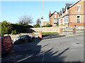
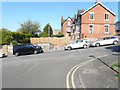
Leyburne House, 86, Leyburne Road
This was Image before the new vehicular access and parking had been constructed.
Image: © John Baker
Taken: 18 Jan 2020
0.02 miles
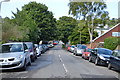
3
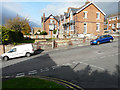
Leyburne House, 86, Leyburne Road
Seen across Taswell Street, planning permission has been granted by Dover District Council under application number 18/00463 for the “conversion of single dwelling into 2 dwelling houses, erection of side porch extension, installation and alterations to windows, erection of shed/bin stores, new vehicular access and parking (existing rear lean-to, porch and garden shed to be demolished)”.
This was Image after its conversion and this was Image after the new vehicular access and parking had been constructed.
Image: © John Baker
Taken: 9 Nov 2018
0.02 miles
4
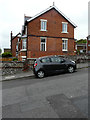
Leyburne House, 86, Leyburne Road
This was Image during its conversion from one house into two.
Image: © John Baker
Taken: 17 May 2019
0.02 miles
5
Leyburne House, 86, Leyburne Road
This view of Image shows the wall before part of it had been demolished to allow for a new vehicular access.
Image: © John Baker
Taken: 21 Sep 2019
0.02 miles
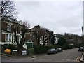
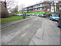
6

Taswell Close
The crane is being used in the construction of the buildings in Image
Image: © John Baker
Taken: 2 Nov 2019
0.03 miles
7
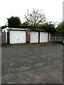
Garage & sheds, Harold Street
Planning permission has been granted by Dover District Council under application number DOV/20/00783 for the “erection of detached dwelling, new vehicle access and parking (existing garage and sheds to be demolished)”.
Image: © John Baker
Taken: 17 Oct 2020
0.05 miles
9
Harold Street
Planning permission has been granted by Dover District Council under application number DOV/16/00095 for the “erection of 2 buildings incorporating 10 self-contained flats and erection of 3 pairs of semi-detached dwellings with associated parking and landscaping”.
This was Image in April 2019.
Image: © John Baker
Taken: 14 Dec 2019
0.06 miles
10
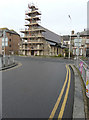
St Paul?s Roman Catholic Church, 103, Maison Dieu Road
I assume the reason for the scaffolding is that restoration, of the stonework, is taking place.
Image: © John Baker
Taken: 16 Jan 2017
0.06 miles