IMAGES TAKEN NEAR TO
Leyburne Road, DOVER, CT16 1SL
Introduction
This page details the photographs taken nearby to Leyburne Road, CT16 1SL by members of the Geograph project.
The Geograph project started in 2005 with the aim of publishing, organising and preserving representative images for every square kilometre of Great Britain, Ireland and the Isle of Man.

There are currently over 7.5m images from over14,400 individuals and you can help contribute to the project by visiting https://www.geograph.org.uk
Image Map (Loading...)


Getting Data...Please wait
Leaflet Map data © OpenStreetMap
Images are licensed for reuse under creativecommons.org/licenses/by-sa/2.0
Notes
- Clicking on the map will re-center to the selected point.
- The higher the marker number, the further away the image location is from the centre of the postcode.
Image Listing (236 Images Found)
Images are licensed for reuse under creativecommons.org/licenses/by-sa/2.0
Image
Details
Distance
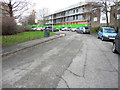
1
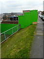
Leyburne Road
The hoarding encloses a building site, where work is ongoing, and includes that along Image
Planning permission has been granted by Dover District Council under application number DOV/16/00095 for the “erection of 2 buildings incorporating 10 self-contained flats and erection of 3 pairs of semi-detached dwellings with associated parking and landscaping”.
Image: © John Baker
Taken: 12 Apr 2019
0.03 miles
2
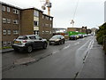
Leyburne Road
The cranes are associated with a housing development for which planning permission has been granted by Dover District Council under application number DOV/16/00095 for the “erection of 2 buildings incorporating 10 self-contained flats and erection of 3 pairs of semi-detached dwellings with associated parking and landscaping”.
The views of this Image and Image show the extent of the development.
Image: © John Baker
Taken: 21 Dec 2019
0.04 miles
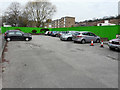
3
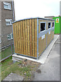
Wheelie bin storage, Leyburne Road
This image of Image shows where the wheelie bins used to be stored. The storage facility has probably been built as the old site is now located behind the hoarding.
Image: © John Baker
Taken: 8 Jun 2019
0.04 miles
4
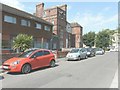
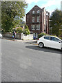
Looking west along Leyburne Road
On the left are Fern Court and the rather magnificently large number 2; beyond are houses in Godwyne Road.
Image: © John Baker
Taken: 18 Jul 2014
0.05 miles
5
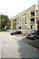
64-120, Harold Street
These were the flats in Image during their construction.
Image: © John Baker
Taken: 21 Aug 2021
0.06 miles
6
Hoarding along Harold Street
This was the site of the former Snelgrove House (used for sheltered housing).
Planning permission has been granted by Dover District Council under application number DOV/16/00095 for the “erection of 2 buildings incorporating 10 self-contained flats and erection of 3 pairs of semi-detached dwellings with associated parking and landscaping”.
Image: © John Baker
Taken: 18 Jul 2014
0.06 miles
7
2, Leyburne Road
The building is having double glazed windows installed.
Image: © John Baker
Taken: 20 Oct 2017
0.06 miles
8
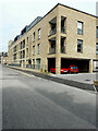
1-24, Bomford House, Harold Street
This was Image during the flats’ construction.
Image: © John Baker
Taken: 21 Aug 2021
0.06 miles
9
Harold Street
Planning permission has been granted by Dover District Council under application number DOV/16/00095 for the “erection of 2 buildings incorporating 10 self-contained flats and erection of 3 pairs of semi-detached dwellings with associated parking and landscaping”.
This was Image in April 2019.
Image: © John Baker
Taken: 14 Dec 2019
0.06 miles
10
Harold Street
The colour of the Image has changed because it has been renewed and painted another colour. The development of the site is ongoing behind it.
Planning permission has been granted by Dover District Council under application number DOV/16/00095 for the “erection of 2 buildings incorporating 10 self-contained flats and erection of 3 pairs of semi-detached dwellings with associated parking and landscaping”.
Image: © John Baker
Taken: 12 Apr 2019
0.06 miles