IMAGES TAKEN NEAR TO
Market Square, DOVER, CT16 1PH
Introduction
This page details the photographs taken nearby to Market Square, CT16 1PH by members of the Geograph project.
The Geograph project started in 2005 with the aim of publishing, organising and preserving representative images for every square kilometre of Great Britain, Ireland and the Isle of Man.

There are currently over 7.5m images from over14,400 individuals and you can help contribute to the project by visiting https://www.geograph.org.uk
Image Map
Images are licensed for reuse under creativecommons.org/licenses/by-sa/2.0
Notes
- Clicking on the map will re-center to the selected point.
- The higher the marker number, the further away the image location is from the centre of the postcode.
Image Listing (1431 Images Found)
Images are licensed for reuse under creativecommons.org/licenses/by-sa/2.0
Image
Details
Distance
1
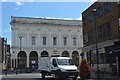
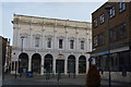
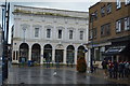
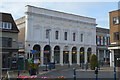
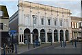
Dover, Market Square
Dover, Market Square, Market Hall in Dover, on the south-western side of Market Square. The alleyway with the brick building on the left hand side is Gaol Lane. The Market Hall was bomb damaged in the Second World War and the façade on the north eastern corner was reduced to just the ground floor. A public convenience was built in this damaged section, and was there in the 1980s, behind two telephone boxes. The telephone boxes and the public conveniences have disappeared when in the 1990s, the old Market Hall site was rebuilt as the White Cliffs Experience Heritage Centre - the northern façade on Market Square was reconstructed and the rest of the building replaced. The building is now Dover Museum. Image
Image: © Helmut Zozmann
Taken: 24 Jul 2011
0.00 miles
2
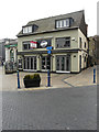
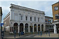
The Burger Bros, Market Square
Fleurets (a firm of chartered surveyors) has affixed a to let board to the frontage of this establishment, which has been shut for several months. This image shows Image when it was open for business.
Image: © John Baker
Taken: 20 Jul 2018
0.00 miles
3
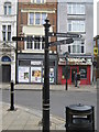
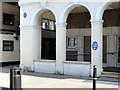
North Downs Way Pointer in Dover
This long distance path starts in Surrey at Farnham then travels along the North Downs. It heads through Surrey and then into Kent and, near Ashford (see Image), it divides into two routes. One heading via Canterbury (pointer heading left) the other via Folkestone (pointer heading right) but both end up in Dover!
The Start/Finish of the trail was originally Dover Market Square, a new trail end is being designed.
See http://www.dadonline.eu/content/north-downs-way-end-trail-marker
Image: © David Anstiss
Taken: 20 Mar 2011
0.00 miles