IMAGES TAKEN NEAR TO
The Gateway, DOVER, CT16 1LJ
Introduction
This page details the photographs taken nearby to The Gateway, CT16 1LJ by members of the Geograph project.
The Geograph project started in 2005 with the aim of publishing, organising and preserving representative images for every square kilometre of Great Britain, Ireland and the Isle of Man.

There are currently over 7.5m images from over14,400 individuals and you can help contribute to the project by visiting https://www.geograph.org.uk
Image Map (1036 Images)


Getting Data...Please wait
Leaflet Map data © OpenStreetMap
Images are licensed for reuse under creativecommons.org/licenses/by-sa/2.0
Notes
- Clicking on the map will re-center to the selected point.
- The higher the marker number, the further away the image location is from the centre of the postcode.
Image Listing (1036 Images Found)
Images are licensed for reuse under creativecommons.org/licenses/by-sa/2.0
Image
Details
Distance
1
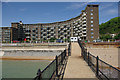
The Gateway, Dover
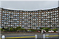
The Gateway is the name given to this huge post-war development on Dover's seafront that replaced an area virtually obliterated by enemy action. This type of architecture is deeply unfashionable today, but these flats are arguably one of the better examples of the genre.
Image: © Stephen McKay
Taken: 25 May 2008
0.01 miles
2
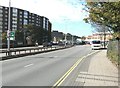
Townwall Street, Dover
The back of The Gateway flats are on the left, while on the right, just beyond the vehicle, is the sports centre.
Image: © John Baker
Taken: 12 Oct 2012
0.02 miles
3
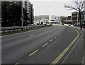
Looking WSW along Townwall Street
On the left stands The Gateway, while on the right, just beyond the lamppost, a hotel is under construction as are retail buildings further along the road. These are part of the ongoing development of St James’ Shopping Centre.
Image: © John Baker
Taken: 22 Oct 2017
0.02 miles
4
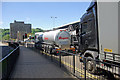
Townwall Street, Dover
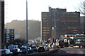
A phalanx of foreign-registered lorries, fresh off the ferry at the Eastern Docks, plods its way through the town headed for the M20.
Image: © Stephen McKay
Taken: 25 May 2008
0.02 miles
6

Port of Dover - 2004
Port of Dover, Breakwater, seen from Dover to Calais Hoverspeed Catamaran Ferry 'SeaCat Diamant'.
Image: © Helmut Zozmann
Taken: Unknown
0.02 miles
7
Dover Castle - On the roof of The Keep, view to Dover centre
Image: © Colin Park
Taken: 23 Sep 2019
0.02 miles
8

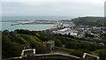
Dover: seafront and Western Docks, from the castle
Along the nearest stretch of seafront are flats along Marine Parade.
Image: © Christopher Hilton
Taken: 5 Apr 2017
0.02 miles
10
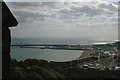
Dover: seafront and Western Docks, from the castle
Along the nearest stretch of seafront are flats along Marine Parade.
Image: © Christopher Hilton
Taken: 5 Apr 2017
0.03 miles