IMAGES TAKEN NEAR TO
Canterbury Road, DOVER, CT15 7HR
Introduction
This page details the photographs taken nearby to Canterbury Road, CT15 7HR by members of the Geograph project.
The Geograph project started in 2005 with the aim of publishing, organising and preserving representative images for every square kilometre of Great Britain, Ireland and the Isle of Man.

There are currently over 7.5m images from over14,400 individuals and you can help contribute to the project by visiting https://www.geograph.org.uk
Image Map
Images are licensed for reuse under creativecommons.org/licenses/by-sa/2.0
Notes
- Clicking on the map will re-center to the selected point.
- The higher the marker number, the further away the image location is from the centre of the postcode.
Image Listing (66 Images Found)
Images are licensed for reuse under creativecommons.org/licenses/by-sa/2.0
Image
Details
Distance
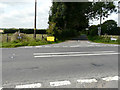
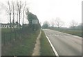
1
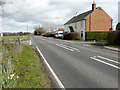
Canterbury Road (A260)
The next left turn is Reece Lane, whose junction is opposite Mill Cottages.
Image: © John Baker
Taken: 8 Mar 2019
0.02 miles
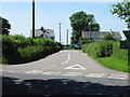
2
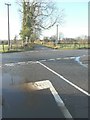
The junction of Reece Lane with Canterbury Road (A260)
On the right hand side, near to the entrance to the lane, there should be a road sign with one arm pointing in the direction of Folkestone and the other to Canterbury. These now lie in the field, beside the A260, while the post, to which they were attached, can just been seen leaning to the right. Large wheel marks along the verge indicate how all this came about.
Image: © John Baker
Taken: 20 Feb 2014
0.03 miles
3
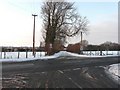
Reece Lane at its junction with the A260
Taken from the road that links the A260 with the Lydden & Dover road. Although the main road had been well gritted, it was at this time that the subject of a shortage of rock salt for the UK's road was in the news.
Image: © John Baker
Taken: 8 Jan 2010
0.03 miles
4
Advanced warning notice, Reece Lane
The notice read: this road will be closed from 06/11/17 [for] 4 days between 09:30 - 15:30. Reece Lane residents received no information about the closure, but a notice, outside the entrance to Blandred Farm, after the work had started, indicated that it was being carried out by contractors on behalf of BT Openreach. Fortunately the lane was only closed for two days, as the work was completed earlier than expected.
A similar Image had been placed here towards the end of August 2017.
Image: © John Baker
Taken: 3 Nov 2017
0.03 miles
5
Warning notice, Reece Lane
The wording reads: Reece Lane - 1 day - road closed here – 31st/8/2017.
The seven households living along the lane were sent a detailed letter by Kent County Council (KCC) about the closure, which was due to take place between 7 am and 7 pm, so that a new surface of micro-asphalt, in two 8mm thick layers, could be laid. We were assured that if it was not possible to carry out the work on this day, due to bad weather, we would be informed of a new date by a letter drop at our homes.
Two days before the work was due to start, it rained all day (and there was a shower the following day). However some time between 9:30 am and 12:30 pm on 1 September, work started and continued until some time after 9:30 am on 3 September (personal experience). This caused some inconvenience to, at least, one householder (me) and some surprise to the workmen from KCC, when a car suddenly appeared (mine), from a direction, which they thought was being monitored, so that no vehicle could reach them. However, the road no longer has any potholes along its length and the micro-asphalt seems to provide a better grip for vehicle tyres.
During the resurfacing, a diversion was in place which took drivers along Hoad Road to turn right into the Image and the Image (which is great ‘fun’ to reverse a car along, when you meet a vehicle coming from the other direction) to where Image was being monitored by a KCC workman, in a van, and a line of cones across the bottom of the hill. Here, drivers turned left to proceed up Golden Hill.
Image: © John Baker
Taken: 25 Aug 2017
0.03 miles
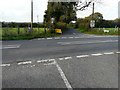
6
Junction with the A260 near Swingfield Minnis
Image: © Nick Smith
Taken: 10 Mar 2007
0.03 miles
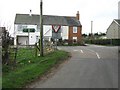
8
The remains of Swingfield and Acrise village hall
In 2004, I took a photo of the hall from the other direction Image During a walk I made on 24 January 2013, I read a notice on the Image about a plan to rebuild this hall and a few days later made a copy of the notice, which was dated November 2012. The content of the notice was a follows:
The Trustees of Densole Playing Field Association have for many years tried, without success, to obtain a suitable piece of land for a playing field in Densole with funds raised by the local community. Following public consultation of Selsted Community Hall in July 2011, Swingfield Parish Council, the Whitecliffs Countryside Project and this Association worked together to produce plans for the development of the Swingfield Village Hall site as it had become available following the destruction of the Village Hall. We are now happy to inform you that comprehensive plans have been drawn up and application for further funding is underway. This has been possible due to the funds held by the Association which will make up approximately 10% of the overall costs. Our funds have been transferred into the Swingfield and Acrise Village Hall & Recreation Ground Charity so that one charity only can organise the funding streams. This is done on the proviso that Clause 2 of our Constitution will be adhered to as follows: “to provide or assist to the provision of a playing field or recreation ground for the benefit of the children or Densole and the neighbourhood in the County of Kent”. We would like to sincerely thank all the people of Densole and surrounding area who have supported this Association over the last 43 years and wish the children many happy hours of interest and play at the proposed project which will be called “The Minnis” Swingfield Acrise & Densole Nature Reserve & Playpark. It is anticipated this work will commence in the coming year.
Image: © John Baker
Taken: 8 Feb 2013
0.03 miles
9
Canterbury Road (A260), Swingfield Minnis in 2004
Of particular interest is the building to the left of the road which was the Swingfield and Acrise village hall until burnt down two years ago see http://www.thisiskent.co.uk/Swingfield-village-hall-suspected-arson/story-12011861-detail/story.html
Image: © John Baker
Taken: 1 Apr 2004
0.04 miles
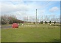
10
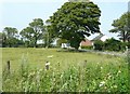
Meadow beside the A260
The notice-board under the tree is advertising the Kent County Show, held this year on 12, 13 and 14 July http://kentshowground.co.uk/ The board shows a picture of a sheep’s head. Two months earlier, the notice-board was advertising another venue Image
Image: © John Baker
Taken: 14 Jul 2013
0.04 miles