IMAGES TAKEN NEAR TO
Wootton Lane, DOVER, CT15 7HH
Introduction
This page details the photographs taken nearby to Wootton Lane, CT15 7HH by members of the Geograph project.
The Geograph project started in 2005 with the aim of publishing, organising and preserving representative images for every square kilometre of Great Britain, Ireland and the Isle of Man.

There are currently over 7.5m images from over14,400 individuals and you can help contribute to the project by visiting https://www.geograph.org.uk
Image Map
Images are licensed for reuse under creativecommons.org/licenses/by-sa/2.0
Notes
- Clicking on the map will re-center to the selected point.
- The higher the marker number, the further away the image location is from the centre of the postcode.
Image Listing (30 Images Found)
Images are licensed for reuse under creativecommons.org/licenses/by-sa/2.0
Image
Details
Distance
1
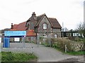
Selsted Church of England Primary School
The old part of the school. There is another building close by but both were closed due to the large amount of snow that had fallen the previous day.
Image: © John Baker
Taken: 12 Mar 2013
0.01 miles
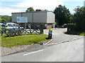
2
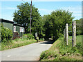
Selsted, Wootton Lane near Primary School
Image: © Helmut Zozmann
Taken: 22 Jul 2011
0.02 miles
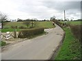
4

Waiting for the children after school
Parents’ cars outside Image Beyond the furthest car, the road had been closed by Kent County Council workmen due to the Image near St Johns Cottages.
Image: © John Baker
Taken: 5 Jan 2016
0.03 miles
5
Stockham Lane at turning for Wootton
Straight on for Selsted. The distance to Wootton given, 1/2 mile, is very optimistic. Even as the crow flies it is about 1.2 miles to the village centre. And if some other concept of 'Wootton' is used, this distance is still in conflict with a far more realistic measure on a sign up the road much closer to Wootton - see Image It would seem that '1' has been lost in transmission and the distance should be '1-1/2'.
Image: © Robin Webster
Taken: 4 Jun 2015
0.03 miles
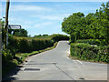
6
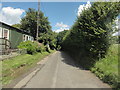
Junction of Wootton Lane next to Selsted School
Image: © Nick Smith
Taken: 10 Mar 2007
0.03 miles
7
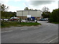
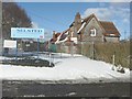
Polling Station, Selsted School
This is the polling station to which I had to go to cast my votes in general and local elections. 7 May was the date of a General Election. The actual name of this part of the school is Selsted Church of England Primary School and Community Hall for Sports and the Arts. Interestingly on the highest and second highest magnification, Selsted is spelt Selstead, on the online map. Another of those idiosyncrasies!
Image: © John Baker
Taken: 7 May 2015
0.04 miles
8
Polling Station, Selsted School
The actual name of this part of the school is Selsted Church of England Primary School and Community Hall for Sports and the Arts. I had cycled here, from my home, to cast my vote (yes) in the European Community (EU) Election as to whether or not the UK should remain in the EU. There had been heavy overnight rain, so bollards had been placed outside the entrance to stop voters slipping on the mud, which had been washed onto the path.
Image: © John Baker
Taken: 23 Jun 2016
0.04 miles