IMAGES TAKEN NEAR TO
Hougham, DOVER, CT15 7DP
Introduction
This page details the photographs taken nearby to CT15 7DP by members of the Geograph project.
The Geograph project started in 2005 with the aim of publishing, organising and preserving representative images for every square kilometre of Great Britain, Ireland and the Isle of Man.

There are currently over 7.5m images from over14,400 individuals and you can help contribute to the project by visiting https://www.geograph.org.uk
Image Map
Images are licensed for reuse under creativecommons.org/licenses/by-sa/2.0
Notes
- Clicking on the map will re-center to the selected point.
- The higher the marker number, the further away the image location is from the centre of the postcode.
Image Listing (10 Images Found)
Images are licensed for reuse under creativecommons.org/licenses/by-sa/2.0
Image
Details
Distance
1
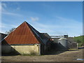
Barn in Poulton Farm
This farm is at the end of Coombe Road (from Dover). It looked to be a cattle farm but not recently used. A bridleway passes through the farm and becomes a byway to Abbey Road near West Hougham.
Image: © David Anstiss
Taken: 27 Feb 2011
0.03 miles
2
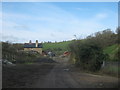
Bridleway to Poulton Farm
This farm is at the end of Coombe Road (from Dover). A bridleway (track leads to the farm, then a byway leads onwards past Bramble Hill (in the background, on the right) towards Abbey Road near West Hougham.
Image: © David Anstiss
Taken: 27 Feb 2011
0.05 miles
3
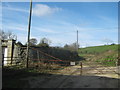
Gate near Poulton Farm
This farm gate is the start of a byway towards Abbey Road. It leads from the farm on Coombe Road. Bramble Hill is seen in the background on the right.
Image: © David Anstiss
Taken: 27 Feb 2011
0.08 miles
4
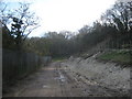
Bridleway to Coombe Road
A byway from Abbey Road near West Hougham, heads to Poulton Farm then a track (also a bridleway) heads towards the road leading towards Dover.
Beyond the fence on the left is a motorbike racing track. See Image
Image: © David Anstiss
Taken: 27 Feb 2011
0.10 miles
5
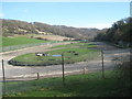
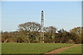
Poulton Farm Racing Track
This off-road figure of eight track is near Poulton Farm at the end of Coombe Road.
In the background is Limekiln Wood on Sainfoin Hill.
Image: © David Anstiss
Taken: 27 Feb 2011
0.10 miles
6
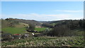
View over Poulton Farm
As seen from the bridleway near Copt Hill Farm.
Looks along the Coombe Road Valley. Long Wood is on the left and Square Wood is on the right.
Image: © David Anstiss
Taken: 27 Feb 2011
0.13 miles
7
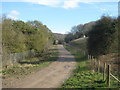
Bridleway to Coombe Road (2)
A byway from Abbey Road near West Hougham, heads to Poulton Farm then a track (also a bridleway) heads towards the road leading towards Dover.
Beyond the fence on the left is a motorbike racing track. See Image
On the right is Joiners Hill.
Image: © David Anstiss
Taken: 27 Feb 2011
0.14 miles
8
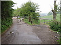
End of the road
Coombe Road ends in a rather sudden double gate, not much room to turn around.
Image: © Nick Smith
Taken: 29 Apr 2007
0.22 miles
10
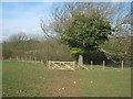
Gate on Park Hill
This gate is on a bridleway from Long Wood leading towards another bridleway / track near Poulton Farm.
Image: © David Anstiss
Taken: 27 Feb 2011
0.23 miles