IMAGES TAKEN NEAR TO
Abbey Road, DOVER, CT15 7DL
Introduction
This page details the photographs taken nearby to Abbey Road, CT15 7DL by members of the Geograph project.
The Geograph project started in 2005 with the aim of publishing, organising and preserving representative images for every square kilometre of Great Britain, Ireland and the Isle of Man.

There are currently over 7.5m images from over14,400 individuals and you can help contribute to the project by visiting https://www.geograph.org.uk
Image Map
Images are licensed for reuse under creativecommons.org/licenses/by-sa/2.0
Notes
- Clicking on the map will re-center to the selected point.
- The higher the marker number, the further away the image location is from the centre of the postcode.
Image Listing (53 Images Found)
Images are licensed for reuse under creativecommons.org/licenses/by-sa/2.0
Image
Details
Distance
1
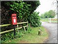
Post box and entrance to St Radigund's Abbey Farm
Image: © Nick Smith
Taken: 29 Apr 2007
0.02 miles
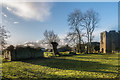
3
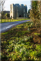
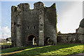
Remains of St Radegund's Abbey
Looking towards the gatehouse in the ruins of St Radegund's Abbey, with a clump of snowdrops in the foreground. The gatehouse is the former tower of the abbey church, converted into a gatehouse by Simon Edolph after he bought the site in 1590. Grade II* listed along with the rest of the extant ruins - see https://www.historicengland.org.uk/listing/the-list/list-entry/1070023.
Image: © Ian Capper
Taken: 7 Feb 2016
0.05 miles
4
Remains of St Radegund's Abbey
Looking towards the ruins of St Radegund's Abbey, with the gatehouse on the right. The gatehouse is the former tower of the abbey church, converted into a gatehouse by Simon Edolph after he bought the site in 1590. Grade II* listed along with the rest of the extant ruins - see https://www.historicengland.org.uk/listing/the-list/list-entry/1070023.
Image: © Ian Capper
Taken: 7 Feb 2016
0.06 miles
5
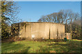
Water reservoir
Water reservoir by entrance to St Radigund's Abbey Farm.
Image: © Ian Capper
Taken: 7 Feb 2016
0.06 miles
6
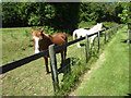
Horses near St Radegund's Abbey
These horses were next to the driveway leading from Abbey Road to St Radegund's Abbey.
Image: © Marathon
Taken: 22 Jun 2019
0.07 miles
7
Remains of St Radegund's Abbey
Part of the ruins of St Radegund's Abbey, with the gatehouse on the right. The gatehouse is the former tower of the abbey church, converted into a gatehouse by Simon Edolph after he bought the site in 1590. Grade II* listed along with the rest of the extant ruins - see https://www.historicengland.org.uk/listing/the-list/list-entry/1070023.
Image: © Ian Capper
Taken: 7 Feb 2016
0.08 miles
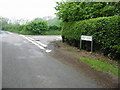
8
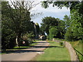
Track to St Radigund's Abbey
From Abbey Road.
Image: © Oast House Archive
Taken: 17 Jul 2010
0.08 miles
9
Gatehouse, St Radegund's Abbey
The gatehouse of St Radegund's Abbey. The gatehouse is the former tower of the abbey church, converted into a gatehouse by Simon Edolph after he bought the site in 1590. Grade II* listed along with the rest of the extant ruins - see https://www.historicengland.org.uk/listing/the-list/list-entry/1070023.
Image: © Ian Capper
Taken: 7 Feb 2016
0.10 miles
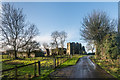
10
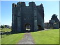
The tower of St Radegund's Abbey
Pevsner in 'The Buildings of England: North East and East Kent' says of St Radegund's: "These mutilated, ivy-clad ruins, high on the lonely chalk plateau behind Dover, are apart from the two cathedrals, the most extensive monastic remains in the county... St Radegund's was founded in 1192 or 1193, one of the two English Premonstratensian abbeys colonised directly from Premontre (the other was Bayham in East Sussex - see https://www.geograph.org.uk/photo/6145555 ). It did not flourish at once .. during the 13th century however came a church on no mean scale, and the usual monastic buildings to the south. In 1590 Simon Edolph bought the deserted buildings, made a house out of the refectory, and used the church tower as a gatehouse."
A footpath runs past the north side of the Abbey ruins, which unlike Bayham, is inaccessible. It can only be viewed from the footpath as seen here. The tower stood on the north side of the aisleless nave.
Image: © Marathon
Taken: 22 Jun 2019
0.10 miles