The tower of St Radegund's Abbey
Introduction
The photograph on this page of The tower of St Radegund's Abbey by Marathon as part of the Geograph project.
The Geograph project started in 2005 with the aim of publishing, organising and preserving representative images for every square kilometre of Great Britain, Ireland and the Isle of Man.

There are currently over 7.5m images from over 14,400 individuals and you can help contribute to the project by visiting https://www.geograph.org.uk
The tower of St Radegund's Abbey
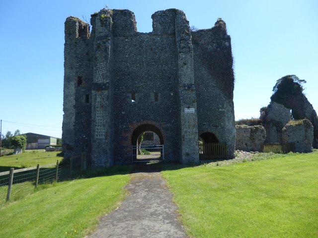
Image: © Marathon Taken: 22 Jun 2019
Pevsner in 'The Buildings of England: North East and East Kent' says of St Radegund's: "These mutilated, ivy-clad ruins, high on the lonely chalk plateau behind Dover, are apart from the two cathedrals, the most extensive monastic remains in the county... St Radegund's was founded in 1192 or 1193, one of the two English Premonstratensian abbeys colonised directly from Premontre (the other was Bayham in East Sussex - see https://www.geograph.org.uk/photo/6145555 ). It did not flourish at once .. during the 13th century however came a church on no mean scale, and the usual monastic buildings to the south. In 1590 Simon Edolph bought the deserted buildings, made a house out of the refectory, and used the church tower as a gatehouse." A footpath runs past the north side of the Abbey ruins, which unlike Bayham, is inaccessible. It can only be viewed from the footpath as seen here. The tower stood on the north side of the aisleless nave.
Images are licensed for reuse under creativecommons.org/licenses/by-sa/2.0
Image Location
Latitude
51.132052
Longitude
1.250707