IMAGES TAKEN NEAR TO
Stonyway Lane, DOVER, CT15 7AN
Introduction
This page details the photographs taken nearby to Stonyway Lane, CT15 7AN by members of the Geograph project.
The Geograph project started in 2005 with the aim of publishing, organising and preserving representative images for every square kilometre of Great Britain, Ireland and the Isle of Man.

There are currently over 7.5m images from over14,400 individuals and you can help contribute to the project by visiting https://www.geograph.org.uk
Image Map
Images are licensed for reuse under creativecommons.org/licenses/by-sa/2.0
Notes
- Clicking on the map will re-center to the selected point.
- The higher the marker number, the further away the image location is from the centre of the postcode.
Image Listing (42 Images Found)
Images are licensed for reuse under creativecommons.org/licenses/by-sa/2.0
Image
Details
Distance
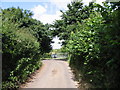
1
Looking NE on outskirts of Church Hougham
The road sign reads Elms Vale 1 1/2(miles)
Image: © Nick Smith
Taken: 20 Jul 2008
0.01 miles
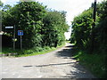
4
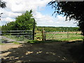
Footpath junction near Parsonage Villas
A track (with public access) from Doctor's Lane in Church Hougham leads past Parsonage Villas towards West Down. A footpath (on the right) leads through a field towards Broomfield Wood.
Image: © David Anstiss
Taken: 27 Feb 2011
0.05 miles
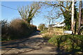
9
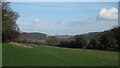
View of Dover Castle
As seen from Plough Hill, lane near Church Hougham.
Elms Wood is on the left in the background.
Image: © David Anstiss
Taken: 27 Feb 2011
0.11 miles