IMAGES TAKEN NEAR TO
Sea Street, DOVER, CT15 6SS
Introduction
This page details the photographs taken nearby to Sea Street, CT15 6SS by members of the Geograph project.
The Geograph project started in 2005 with the aim of publishing, organising and preserving representative images for every square kilometre of Great Britain, Ireland and the Isle of Man.

There are currently over 7.5m images from over14,400 individuals and you can help contribute to the project by visiting https://www.geograph.org.uk
Image Map
Images are licensed for reuse under creativecommons.org/licenses/by-sa/2.0
Notes
- Clicking on the map will re-center to the selected point.
- The higher the marker number, the further away the image location is from the centre of the postcode.
Image Listing (73 Images Found)
Images are licensed for reuse under creativecommons.org/licenses/by-sa/2.0
Image
Details
Distance
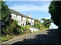
2
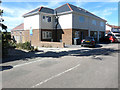
Business premises, The Droveway
Shelly's Tea Rooms (on the left) and Deli & Gift Shop (on the right). Seen across Sea Street.
Image: © John Baker
Taken: 16 Dec 2012
0.03 miles
3
4 & 5, The Droveway
This image shows Image in June 2018.
Image: © John Baker
Taken: 16 Dec 2012
0.04 miles
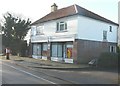
4
4 & 5, The Droveway
Planning permission has been granted by Dover District Council under application number DOV/16/00007 for the “erection of 2 semi-detached dwellings with integral carports and attached private garage; erection of 1 attached dwelling; conversion of existing ground floor shop into a self-contained flat, and associated parking and landscaping (existing garages to be demolished)”.
The new houses are to be erected beside and at the back of the existing building.
These images show Image in 2012 and Image in 2020.
Image: © John Baker
Taken: 24 Jun 2018
0.04 miles
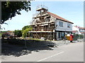
5
4 & 5, The Droveway
This image shows Image in June 2018.
Image: © John Baker
Taken: 30 Jul 2020
0.04 miles
6
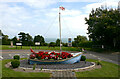
Ornamental boat at St Margaret's at Cliffe
The boat has been named 'The Spirit of St Margaret's', has stood at the junction of Bay Hill and Granville Road since 2012 and was built to commemorate the Olympic Games held that year.
Image: © David Kemp
Taken: 2 Sep 2021
0.05 miles
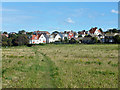
7
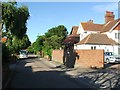
The Droveway, St. Margaret's at Cliffe
Image: © Chris Whippet
Taken: 4 Jul 2015
0.06 miles
8
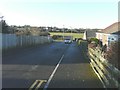
Downside, St Margaret's Bay
A small development of residential dwellings with a view of the church tower across the fields
Image: © John Baker
Taken: 16 Dec 2012
0.06 miles
9
Field footpath, St. Margaret at Cliffe
Not a public right of way, but well used.
Image: © Robin Webster
Taken: 26 Sep 2015
0.07 miles
10
![A walk to the South Foreland Lighthouse and return [36]](https://s2.geograph.org.uk/geophotos/07/10/40/7104090_d36ad406_120x120.jpg)
A walk to the South Foreland Lighthouse and return [36]
A boat in a roundabout.
Starting from the church at St Margaret’s at Cliffe, the walk passes through housing then over the flank of Bay Hill. Continuing through an area of scrub laid out with roads (presumably for a housing development that was never built) the lighthouse is reached. The return route is along the cliff tops to the lower part of St Margaret’s at Cliffe before a steep ascent of Bay Hill back to the church.
Image: © Michael Dibb
Taken: 13 Sep 2021
0.07 miles