IMAGES TAKEN NEAR TO
The Rise, DOVER, CT15 6DB
Introduction
This page details the photographs taken nearby to The Rise, CT15 6DB by members of the Geograph project.
The Geograph project started in 2005 with the aim of publishing, organising and preserving representative images for every square kilometre of Great Britain, Ireland and the Isle of Man.

There are currently over 7.5m images from over14,400 individuals and you can help contribute to the project by visiting https://www.geograph.org.uk
Image Map
Images are licensed for reuse under creativecommons.org/licenses/by-sa/2.0
Notes
- Clicking on the map will re-center to the selected point.
- The higher the marker number, the further away the image location is from the centre of the postcode.
Image Listing (67 Images Found)
Images are licensed for reuse under creativecommons.org/licenses/by-sa/2.0
Image
Details
Distance
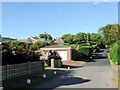
1
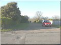
The Rise, St Margaret's Bay
Seen from its junction with The Droveway.
Image: © John Baker
Taken: 21 Dec 2012
0.03 miles
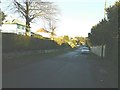
2
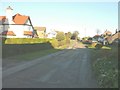
The Droveway, St Margaret's Bay
In the far distance, below a tree on the right side of the road, is a fingerpost indicating the footpath that links this road to Salisbury Road.
Image: © John Baker
Taken: 21 Dec 2012
0.05 miles
3
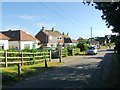
The Droveway, St. Margaret's at Cliffe
Image: © Chris Whippet
Taken: 4 Jul 2015
0.05 miles
4
![A walk from St Margaret?s at Cliffe to Kingsdown and return [62]](https://s3.geograph.org.uk/geophotos/07/08/68/7086855_f445db2d_120x120.jpg)
A walk from St Margaret?s at Cliffe to Kingsdown and return [62]
This footpath leaves The Droveway and descends to Salisbury Road.
Starting from the Dover Patrol Monument, the walk follows the long distance Saxon Shore Way along the top of the cliffs before descending to the bay at Kingsdown. Heading inland there is an ascent of Wood Hill before various rights of way run across fields to the wonderfully named Otty Bottom, then on to Free Down and a return to the starting point. A little more than 5 miles.
Image: © Michael Dibb
Taken: 12 Sep 2021
0.06 miles
5
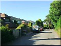
The Droveway, St. Margaret's at Cliffe
Image: © Chris Whippet
Taken: 4 Jul 2015
0.10 miles
6
![A walk from St Margaret?s at Cliffe to Kingsdown and return [63]](https://s0.geograph.org.uk/geophotos/07/08/68/7086856_28be4b1f_120x120.jpg)
A walk from St Margaret?s at Cliffe to Kingsdown and return [63]
The footpath from The Droveway ends at Salisbury Road.
Starting from the Dover Patrol Monument, the walk follows the long distance Saxon Shore Way along the top of the cliffs before descending to the bay at Kingsdown. Heading inland there is an ascent of Wood Hill before various rights of way run across fields to the wonderfully named Otty Bottom, then on to Free Down and a return to the starting point. A little more than 5 miles.
Image: © Michael Dibb
Taken: 12 Sep 2021
0.11 miles
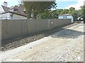
7
Salisbury Road, St. Margaret's at Cliffe
Image: © Chris Whippet
Taken: 4 Jul 2015
0.11 miles
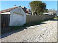
9
Recently erected garage at East Loxley, 44 Salisbury Road
In November 2013, work had not been completed on Image This is a view from Victoria Road.
Image: © John Baker
Taken: 13 Jul 2014
0.14 miles
10
East Loxley, 44 Salisbury Road
Planning permission has been granted by Dover District Council under application number DOV/12/00494 for the “erection of side and rear extensions and a detached garage, together with construction of a vehicular access and 2m boundary fence (existing conservatory, lean-to and side extensions to be demolished)”. This view, from Victoria Avenue, shows the garage under construction with the house to its left.
Image: © John Baker
Taken: 10 Nov 2013
0.14 miles